
Topografische Karte Ellesmere Island
Interaktive Karte
Klicken Sie auf die Karte, um die Höhe anzuzeigen.
Über diese Karte
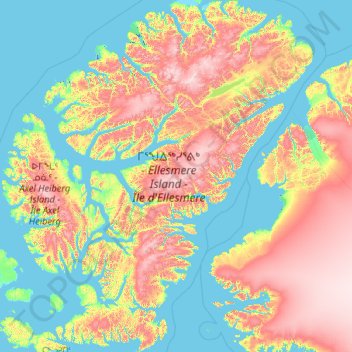
Name: Topografische Karte Ellesmere Island, Höhe, Relief.
Ort: Ellesmere Island, Nunavut, X0A 0J0, Canada (76.13171 -91.90137 83.11148 -61.09132)
Durchschnittliche Höhe: 495 m
Minimale Höhe: -5 m
Maximale Höhe: 2.446 m
Andere topografische Karten
Klicken Sie auf eine Karte, um ihre Topografie, ihre Höhe und ihr Relief anzuzeigen.
Pond Inlet (Mittimatalik)
Canada > Nunavut > Pond Inlet (Mittimatalik)
Pond Inlet (Mittimatalik), Qikiqtaaluk Region, Nunavut, Canada
Durchschnittliche Höhe: 82 m
Amund Ringnes Island
Amund Ringnes Island, Nunavut, Canada
Durchschnittliche Höhe: 22 m
Sermilik Glacier
Sermilik Glacier, Sirmilik National Park, Nunavut, Canada
Durchschnittliche Höhe: 1.188 m
Prince of Wales Island
Prince of Wales Island, Nunavut, Canada
Durchschnittliche Höhe: 31 m
Axel Heiberg Island
Axel Heiberg Island, Nunavut, Canada
Durchschnittliche Höhe: 263 m
Keewatin Region
Keewatin Region, Nunavut, X0C 0J0, Canada
Durchschnittliche Höhe: 134 m
Challenger Mountains
Challenger Mountains, Nunavut, Canada
Durchschnittliche Höhe: 611 m
King Christian Island
King Christian Island, Nunavut, Canada
Durchschnittliche Höhe: 18 m
Prince Charles Island
Prince Charles Island, Nunavut, Canada
Durchschnittliche Höhe: 17 m
British Empire Range
British Empire Range, Nunavut, Canada
Durchschnittliche Höhe: 1.431 m