
Topografische Karte Peaslee Lake
Interaktive Karte
Klicken Sie auf die Karte, um die Höhe anzuzeigen.
Über diese Karte
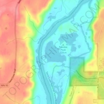
Name: Topografische Karte Peaslee Lake, Höhe, Relief.
Durchschnittliche Höhe: 241 m
Minimale Höhe: 205 m
Maximale Höhe: 289 m
Andere topografische Karten
Klicken Sie auf eine Karte, um ihre Topografie, ihre Höhe und ihr Relief anzuzeigen.
Osceola
United States > Wisconsin > Polk County
Osceola, Polk County, Wisconsin, United States
Durchschnittliche Höhe: 261 m
Luck
United States > Wisconsin > Polk County
Luck, Polk County, Wisconsin, United States
Durchschnittliche Höhe: 379 m
Wild River State Park
United States > Wisconsin > Polk County
Wild River State Park, Town of Sterling, Polk County, Wisconsin, 54006, United States
Durchschnittliche Höhe: 262 m
Balsam Lake
United States > Wisconsin > Polk County
Balsam Lake, Polk County, Wisconsin, United States
Durchschnittliche Höhe: 354 m
Town of Bone Lake
United States > Wisconsin > Polk County
Town of Bone Lake, Polk County, Wisconsin, United States
Durchschnittliche Höhe: 378 m
Clayton
United States > Wisconsin > Polk County
Clayton, Polk County, Wisconsin, United States
Durchschnittliche Höhe: 370 m
Frederic
United States > Wisconsin > Polk County
Frederic, Polk County, Wisconsin, United States
Durchschnittliche Höhe: 373 m
Little Falls
United States > Wisconsin > Polk County
Little Falls, Town of Alden, Polk County, Wisconsin, United States
Durchschnittliche Höhe: 326 m
Clear Lake Village Park
United States > Wisconsin > Polk County > Clear Lake
Clear Lake Village Park, Clear Lake, Town of Clear Lake, Polk County, Wisconsin, United States
Durchschnittliche Höhe: 368 m
Cushing
United States > Wisconsin > Polk County
Cushing, Town of Laketown, Polk County, Wisconsin, 54006, United States
Durchschnittliche Höhe: 298 m
Amery
United States > Wisconsin > Polk County
Amery, Polk County, Wisconsin, United States
Durchschnittliche Höhe: 330 m
Clear Lake
United States > Wisconsin > Polk County
Clear Lake, Polk County, Wisconsin, United States
Durchschnittliche Höhe: 362 m