
Topografische Karte Mill Creek
Interaktive Karte
Klicken Sie auf die Karte, um die Höhe anzuzeigen.
Über diese Karte
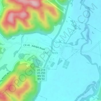
Name: Topografische Karte Mill Creek, Höhe, Relief.
Ort: Mill Creek, Randolph County, West Virginia, United States (38.72707 -79.98163 38.73703 -79.96025)
Durchschnittliche Höhe: 651 m
Minimale Höhe: 604 m
Maximale Höhe: 807 m
Andere topografische Karten
Klicken Sie auf eine Karte, um ihre Topografie, ihre Höhe und ihr Relief anzuzeigen.
Osceola
United States > West Virginia > Randolph County
Osceola, Randolph County, West Virginia, 26296, United States
Durchschnittliche Höhe: 1.123 m
Elkins
United States > West Virginia > Randolph County
Elkins, Randolph County, West Virginia, 26241, United States
Durchschnittliche Höhe: 637 m
Bemis
United States > West Virginia > Randolph County
Bemis, Randolph County, West Virginia, 26268, United States
Durchschnittliche Höhe: 958 m
Glady
United States > West Virginia > Randolph County
Glady, Randolph County, West Virginia, 26268, United States
Durchschnittliche Höhe: 943 m
Montrose
United States > West Virginia > Randolph County
Montrose, Randolph County, West Virginia, United States
Durchschnittliche Höhe: 630 m
Whitmer
United States > West Virginia > Randolph County
Whitmer, Randolph County, West Virginia, United States
Durchschnittliche Höhe: 972 m
Adolph
United States > West Virginia > Randolph County
Adolph, Randolph County, West Virginia, 26280, United States
Durchschnittliche Höhe: 821 m
Kumbrabow State Forest
United States > West Virginia > Randolph County
Kumbrabow State Forest, Randolph County, West Virginia, United States
Durchschnittliche Höhe: 1.013 m
Harman
United States > West Virginia > Randolph County > Harman
Harman, Randolph County, West Virginia, 26760, United States
Durchschnittliche Höhe: 814 m
Blue Spring
United States > West Virginia > Randolph County
Blue Spring, Randolph County, West Virginia, 26282, United States
Durchschnittliche Höhe: 939 m
White Top
United States > West Virginia > Randolph County
White Top, Randolph County, West Virginia, United States
Durchschnittliche Höhe: 1.159 m
Bickle Knob
United States > West Virginia > Randolph County
Bickle Knob, Randolph County, West Virginia, United States
Durchschnittliche Höhe: 982 m
Valley Head
United States > West Virginia > Randolph County > Valley Head
Valley Head, Randolph County, West Virginia, 26294, United States
Durchschnittliche Höhe: 874 m
Dryfork
United States > West Virginia > Randolph County > Dryfork
Dryfork, Randolph County, West Virginia, 26289, United States
Durchschnittliche Höhe: 755 m
Pumpkintown
United States > West Virginia > Randolph County
Pumpkintown, Randolph County, West Virginia, 26278, United States
Durchschnittliche Höhe: 743 m