
Topografische Karte Ottappalam
Interaktive Karte
Klicken Sie auf die Karte, um die Höhe anzuzeigen.
Über diese Karte
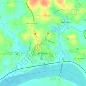
Name: Topografische Karte Ottappalam, Höhe, Relief.
Ort: Ottappalam, Palakkad district, Kerala, 679101, India (10.76696 76.37241 10.78577 76.38920)
Durchschnittliche Höhe: 41 m
Minimale Höhe: 22 m
Maximale Höhe: 76 m
Ottapalam is located at 10°46′N 76°23′E / 10.77°N 76.38°E / 10.77; 76.38. It has an average elevation of 54 m (177 ft).
Andere topografische Karten
Klicken Sie auf eine Karte, um ihre Topografie, ihre Höhe und ihr Relief anzuzeigen.
Shoranur
India > Kerala > Ottappalam > Shoranur
Shoranur, Ottappalam, Palakkad district, Kerala, 679121, India
Durchschnittliche Höhe: 47 m
Vaniyamkulam
India > Kerala > Ottappalam > Chorottur
Vaniyamkulam, Chorottur, Ottappalam, Palakkad district, Kerala, India
Durchschnittliche Höhe: 57 m