
Spenden
Rüsten Sie sich für Ihr nächstes Abenteuer:
Als Amazon-Partner erhält diese Website eine Provision für qualifizierte Käufe, ohne zusätzliche Kosten für Sie.
Topografische Karte Gulf Shores
Klicken Sie auf die Karte, um die Höhe anzuzeigen.
Spenden
Rüsten Sie sich für Ihr nächstes Abenteuer:
Als Amazon-Partner erhält diese Website eine Provision für qualifizierte Käufe, ohne zusätzliche Kosten für Sie.
Gulf Shores
Jack Edwards National Airport is located in Gulf Shores and offers services from Gulf Air Center, Salt Air Aviation Center and Platium Air Center. The airport is located in town, two miles from the beach. Their FBO Gulf Air Center will provide a rental vehicle while they take care of fueling and storing aircraft. There is 48-hour and long term parking available. The longest paved runway extends 6,962 feet. The facility is at an elevation of 17 feet. They offer outside tiedown as well as hangar space for aircraft. They can provide space by the night, week or month.
Spenden
Rüsten Sie sich für Ihr nächstes Abenteuer:
Als Amazon-Partner erhält diese Website eine Provision für qualifizierte Käufe, ohne zusätzliche Kosten für Sie.
Über diese Karte
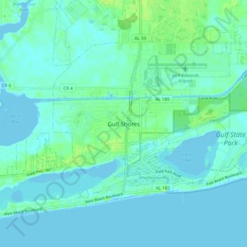
Name: Topografische Karte Gulf Shores, Höhe, Relief.
Ort: Gulf Shores, Baldwin County, Alabama, 36542, United States (30.23112 -87.72938 30.31112 -87.64938)
Durchschnittliche Höhe: 4 m
Minimale Höhe: -3 m
Maximale Höhe: 18 m
Spenden
Rüsten Sie sich für Ihr nächstes Abenteuer:
Als Amazon-Partner erhält diese Website eine Provision für qualifizierte Käufe, ohne zusätzliche Kosten für Sie.
Andere topografische Karten
Klicken Sie auf eine Karte, um ihre Topografie, ihre Höhe und ihr Relief anzuzeigen.
Fairhope
United States > Alabama > Baldwin County > Fairhope
According to the U.S. Census Bureau, the city has a total area of 12.0 square miles (31.1 km2), of which 0.019 square mile (0.05 km2), or 0.16%, is water. Its elevation ranges from sea level at the bay to 122 feet (37 m) in the city center.
Durchschnittliche Höhe: 35 m
Spenden
Rüsten Sie sich für Ihr nächstes Abenteuer:
Als Amazon-Partner erhält diese Website eine Provision für qualifizierte Käufe, ohne zusätzliche Kosten für Sie.
Fairhope
United States > Alabama > Baldwin County > Fairhope
According to the U.S. Census Bureau, the city has a total area of 12.0 square miles (31.1 km2), of which 0.019 square mile (0.05 km2), or 0.16%, is water. Its elevation ranges from sea level at the bay to 122 feet (37 m) in the city center.
Durchschnittliche Höhe: 35 m