
Spenden
Rüsten Sie sich für Ihr nächstes Abenteuer:
Als Amazon-Partner erhält diese Website eine Provision für qualifizierte Käufe, ohne zusätzliche Kosten für Sie.
Topografische Karte Sugar Hill
Klicken Sie auf die Karte, um die Höhe anzuzeigen.
Spenden
Rüsten Sie sich für Ihr nächstes Abenteuer:
Als Amazon-Partner erhält diese Website eine Provision für qualifizierte Käufe, ohne zusätzliche Kosten für Sie.
Sugar Hill
According to the United States Census Bureau, as of 2010 the city of Sugar Hill had a total land area of 10.6 square miles (27.5 km2), of which 0.04 square miles (0.1 km2), or 0.33%, was water. The U.S. Geological Survey lists the city's elevation as 1,149 feet (350 m).
Spenden
Rüsten Sie sich für Ihr nächstes Abenteuer:
Als Amazon-Partner erhält diese Website eine Provision für qualifizierte Käufe, ohne zusätzliche Kosten für Sie.
Über diese Karte
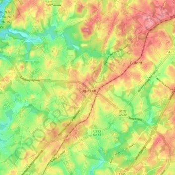
Name: Topografische Karte Sugar Hill, Höhe, Relief.
Ort: Sugar Hill, Gwinnett County, Georgia, 30518, United States (34.06466 -84.10169 34.15187 -84.01418)
Durchschnittliche Höhe: 332 m
Minimale Höhe: 277 m
Maximale Höhe: 383 m
Spenden
Rüsten Sie sich für Ihr nächstes Abenteuer:
Als Amazon-Partner erhält diese Website eine Provision für qualifizierte Käufe, ohne zusätzliche Kosten für Sie.
Andere topografische Karten
Klicken Sie auf eine Karte, um ihre Topografie, ihre Höhe und ihr Relief anzuzeigen.
Yellow River Post Office Site
United States > Georgia > Gwinnett County > Lilburn
Durchschnittliche Höhe: 275 m
Spenden
Rüsten Sie sich für Ihr nächstes Abenteuer:
Als Amazon-Partner erhält diese Website eine Provision für qualifizierte Käufe, ohne zusätzliche Kosten für Sie.
Pine Ridge Country Club Estates
United States > Georgia > Gwinnett County > Lawrenceville
Durchschnittliche Höhe: 323 m
Spenden
Rüsten Sie sich für Ihr nächstes Abenteuer:
Als Amazon-Partner erhält diese Website eine Provision für qualifizierte Käufe, ohne zusätzliche Kosten für Sie.