
Spenden
Rüsten Sie sich für Ihr nächstes Abenteuer:
Als Amazon-Partner erhält diese Website eine Provision für qualifizierte Käufe, ohne zusätzliche Kosten für Sie.
Topografische Karte Midlothian
Klicken Sie auf die Karte, um die Höhe anzuzeigen.
Spenden
Rüsten Sie sich für Ihr nächstes Abenteuer:
Als Amazon-Partner erhält diese Website eine Provision für qualifizierte Käufe, ohne zusätzliche Kosten für Sie.
Über diese Karte
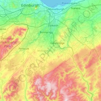
Name: Topografische Karte Midlothian, Höhe, Relief.
Ort: Midlothian, Scotland, United Kingdom (55.71035 -3.36904 55.93202 -2.84631)
Durchschnittliche Höhe: 236 m
Minimale Höhe: 0 m
Maximale Höhe: 658 m
Spenden
Rüsten Sie sich für Ihr nächstes Abenteuer:
Als Amazon-Partner erhält diese Website eine Provision für qualifizierte Käufe, ohne zusätzliche Kosten für Sie.
Andere topografische Karten
Klicken Sie auf eine Karte, um ihre Topografie, ihre Höhe und ihr Relief anzuzeigen.
Edinburgh
United Kingdom > Scotland > Edinburgh
Some have called Edinburgh the Athens of the North for a variety of reasons. The earliest comparison between the two cities showed that they had a similar topography, with the Castle Rock of Edinburgh performing a similar role to the Athenian Acropolis. Both of them had flatter, fertile agricultural land…
Durchschnittliche Höhe: 104 m
Glasgow
United Kingdom > Scotland > Glasgow City
Glasgow itself was reputed to have been founded by the Christian missionary Saint Mungo in the 6th century. He established a church on the Molendinar Burn, where the present Glasgow Cathedral stands, and in the following years Glasgow became a religious centre. Glasgow grew over the following centuries. The…
Durchschnittliche Höhe: 128 m
Aberlour
United Kingdom > Scotland > Moray
According to the 1846 A Topographical Dictionary of Scotland, "This parish, formerly called Skirdustan, signifying, in the Gaelic tongue, 'the division of Dustan', its tutelary saint, derived its present name from its situation at the mouth of a noisy burn, which discharges itself into the river Spey."
Durchschnittliche Höhe: 160 m
Spenden
Rüsten Sie sich für Ihr nächstes Abenteuer:
Als Amazon-Partner erhält diese Website eine Provision für qualifizierte Käufe, ohne zusätzliche Kosten für Sie.
Scottish Highlands
United Kingdom > Scotland > Highland
The entire region was covered by ice sheets during the Pleistocene ice ages, save perhaps for a few nunataks. The complex geomorphology includes incised valleys and lochs carved by the action of mountain streams and ice, and a topography of irregularly distributed mountains whose summits have similar heights…
Durchschnittliche Höhe: 907 m
Dundee
United Kingdom > Scotland > Dundee City
Dundee sits on the north bank of the Firth of Tay on the eastern, North Sea Coast of Scotland. The city lies 36.1 miles (58 km) NNE of Edinburgh and 360.6 miles (580 km) NNW of London. The built-up area occupies a roughly rectangular shape 8.3 miles (13 km) long by 2.5 miles (4 km) wide, aligned in an east to…
Durchschnittliche Höhe: 82 m
Airdrie
United Kingdom > Scotland > North Lanarkshire
Airdrie's name first appeared in the Register of the Great Seal of Scotland (Registrum Magni Sigilii Regum Scotorum) in 1373 as Ardre. By 1546 it had become Ardry and by 1587 it was known as Ardrie. In 1630 it finally appeared in the Register as Airdrie. Given the topography of the area, the most likely…
Durchschnittliche Höhe: 135 m
Spenden
Rüsten Sie sich für Ihr nächstes Abenteuer:
Als Amazon-Partner erhält diese Website eine Provision für qualifizierte Käufe, ohne zusätzliche Kosten für Sie.
Spenden
Rüsten Sie sich für Ihr nächstes Abenteuer:
Als Amazon-Partner erhält diese Website eine Provision für qualifizierte Käufe, ohne zusätzliche Kosten für Sie.
Aberdeen
United Kingdom > Scotland > Aberdeen
Two weather stations collect climate data for the area, Aberdeen/Dyce Airport, and Craibstone. Both are about 4 1⁄2 miles (7 km) to the north west of the city centre, and given that they are in close proximity to each other, exhibit very similar climatic regimes. Dyce tends to have marginally warmer daytime…
Durchschnittliche Höhe: 52 m
Spenden
Rüsten Sie sich für Ihr nächstes Abenteuer:
Als Amazon-Partner erhält diese Website eine Provision für qualifizierte Käufe, ohne zusätzliche Kosten für Sie.
Ochil Hills
United Kingdom > Scotland > Perth and Kinross > Auchterarder
Durchschnittliche Höhe: 235 m
Spenden
Rüsten Sie sich für Ihr nächstes Abenteuer:
Als Amazon-Partner erhält diese Website eine Provision für qualifizierte Käufe, ohne zusätzliche Kosten für Sie.
Fort William
United Kingdom > Scotland > Highland
Fort William has an oceanic climate (Cfb) with moderate, but generally cool, temperatures and abundant precipitation. In the towns immediate vicinity, there are significant variations in elevation, which leads to some uninhabited areas near the town having a subpolar oceanic climate (Cfc), or, at the absolute…
Durchschnittliche Höhe: 122 m
Spenden
Rüsten Sie sich für Ihr nächstes Abenteuer:
Als Amazon-Partner erhält diese Website eine Provision für qualifizierte Käufe, ohne zusätzliche Kosten für Sie.
Ben Nevis
United Kingdom > Scotland > Highland
Ben Nevis has a highland (alpine) maritime (oceanic) polar climate (ET climate in the Köppen classification). Ben Nevis's elevation, maritime location and topography frequently lead to cool and cloudy weather conditions, which can pose a danger to ill-equipped walkers. According to the observations carried…
Durchschnittliche Höhe: 912 m
Spenden
Rüsten Sie sich für Ihr nächstes Abenteuer:
Als Amazon-Partner erhält diese Website eine Provision für qualifizierte Käufe, ohne zusätzliche Kosten für Sie.
Ailsa Craig
In a small glen above Ailsa Castle, a small freshwater body known as the Garry Loch is located at an altitude of 247 m (810 ft), with a depth of at least 17 feet.
Durchschnittliche Höhe: 14 m
Spenden
Rüsten Sie sich für Ihr nächstes Abenteuer:
Als Amazon-Partner erhält diese Website eine Provision für qualifizierte Käufe, ohne zusätzliche Kosten für Sie.
Mull of Kintyre
Ailsa Craig and the County Antrim coast of Ulster and Rathlin Island are all clearly visible from the Mull. On clearer days it is also possible to make out Malin Head in Inishowen in County Donegal in the west of Ulster, and the Ayrshire coast on the other side of Ailsa Craig. Other islands in the Firth of…
Durchschnittliche Höhe: 84 m
Spenden
Rüsten Sie sich für Ihr nächstes Abenteuer:
Als Amazon-Partner erhält diese Website eine Provision für qualifizierte Käufe, ohne zusätzliche Kosten für Sie.
Spenden
Rüsten Sie sich für Ihr nächstes Abenteuer:
Als Amazon-Partner erhält diese Website eine Provision für qualifizierte Käufe, ohne zusätzliche Kosten für Sie.
Spenden
Rüsten Sie sich für Ihr nächstes Abenteuer:
Als Amazon-Partner erhält diese Website eine Provision für qualifizierte Käufe, ohne zusätzliche Kosten für Sie.
Spenden
Rüsten Sie sich für Ihr nächstes Abenteuer:
Als Amazon-Partner erhält diese Website eine Provision für qualifizierte Käufe, ohne zusätzliche Kosten für Sie.
Spenden
Rüsten Sie sich für Ihr nächstes Abenteuer:
Als Amazon-Partner erhält diese Website eine Provision für qualifizierte Käufe, ohne zusätzliche Kosten für Sie.
Spenden
Rüsten Sie sich für Ihr nächstes Abenteuer:
Als Amazon-Partner erhält diese Website eine Provision für qualifizierte Käufe, ohne zusätzliche Kosten für Sie.
Spenden
Rüsten Sie sich für Ihr nächstes Abenteuer:
Als Amazon-Partner erhält diese Website eine Provision für qualifizierte Käufe, ohne zusätzliche Kosten für Sie.
Spenden
Rüsten Sie sich für Ihr nächstes Abenteuer:
Als Amazon-Partner erhält diese Website eine Provision für qualifizierte Käufe, ohne zusätzliche Kosten für Sie.
Garden of Cosmic Speculation
United Kingdom > Scotland > Dumfries and Galloway
Durchschnittliche Höhe: 31 m
Seton
United Kingdom > Scotland > East Lothian > Cockenzie and Port Seton
Durchschnittliche Höhe: 33 m
Denholm
United Kingdom > Scotland > Scottish Borders
In Main Street, stands The Text House, a category B listed building, erected about 1910 by John Haddon (1845–1924), a medical doctor and author of published works on public sanitation and dietetics. The 3-storey house is in the arts and craft style. One of the texts on the front elevation is a reminder to…
Durchschnittliche Höhe: 128 m
Spenden
Rüsten Sie sich für Ihr nächstes Abenteuer:
Als Amazon-Partner erhält diese Website eine Provision für qualifizierte Käufe, ohne zusätzliche Kosten für Sie.
Falkirk
United Kingdom > Scotland > Falkirk
Falkirk is located in an area of undulating topography between the Slamannan Plateau and the upper reaches of the Firth of Forth. The area to the north of Falkirk is part of the floodplain of the River Carron. Two tributaries of the River Carron - the East Burn and the West Burn flow through the town and form…
Durchschnittliche Höhe: 69 m
Spenden
Rüsten Sie sich für Ihr nächstes Abenteuer:
Als Amazon-Partner erhält diese Website eine Provision für qualifizierte Käufe, ohne zusätzliche Kosten für Sie.
Spenden
Rüsten Sie sich für Ihr nächstes Abenteuer:
Als Amazon-Partner erhält diese Website eine Provision für qualifizierte Käufe, ohne zusätzliche Kosten für Sie.
Spenden
Rüsten Sie sich für Ihr nächstes Abenteuer:
Als Amazon-Partner erhält diese Website eine Provision für qualifizierte Käufe, ohne zusätzliche Kosten für Sie.
Ballater
United Kingdom > Scotland > Aberdeenshire
Ballater (/ˈbælətər/, Scottish Gaelic: Bealadair) is a village in Aberdeenshire, Scotland, on the River Dee, immediately east of the Cairngorm Mountains. Situated at an elevation of 213 metres (699 feet), Ballater is a centre for hikers and known for its spring water, once said to cure scrofula. It is home…
Durchschnittliche Höhe: 360 m
Spenden
Rüsten Sie sich für Ihr nächstes Abenteuer:
Als Amazon-Partner erhält diese Website eine Provision für qualifizierte Käufe, ohne zusätzliche Kosten für Sie.
Spenden
Rüsten Sie sich für Ihr nächstes Abenteuer:
Als Amazon-Partner erhält diese Website eine Provision für qualifizierte Käufe, ohne zusätzliche Kosten für Sie.
Spenden
Rüsten Sie sich für Ihr nächstes Abenteuer:
Als Amazon-Partner erhält diese Website eine Provision für qualifizierte Käufe, ohne zusätzliche Kosten für Sie.
Spenden
Rüsten Sie sich für Ihr nächstes Abenteuer:
Als Amazon-Partner erhält diese Website eine Provision für qualifizierte Käufe, ohne zusätzliche Kosten für Sie.
Kirkcaldy
United Kingdom > Scotland > Fife
Towards the end of the 16th century, a detailed assessment on the size of the townscape was carried out. The first estimate of the parish population in 1639 was between 3,000 and 3,200 and around 3,400 by 1691. At the beginning of the 18th century, the population declined. A census by Webster's Topographical…
Durchschnittliche Höhe: 50 m
Spenden
Rüsten Sie sich für Ihr nächstes Abenteuer:
Als Amazon-Partner erhält diese Website eine Provision für qualifizierte Käufe, ohne zusätzliche Kosten für Sie.