Geolokalisieren
👉 Easily get elevation data in JSON, GeoTIFF and KML formats using Elevation API
Vielen Dank für die Unterstützung dieser Website ❤️
Spenden

Rüsten Sie sich für Ihr nächstes Abenteuer:

Als Amazon-Partner erhält diese Website eine Provision für qualifizierte Käufe, ohne zusätzliche Kosten für Sie.

Topografische Karte Pensacola

Klicken Sie auf die Karte, um die Höhe anzuzeigen.

Pensacola

The land is sloped up northward from Pensacola Bay, with most of the city at an elevation above that which a potential hurricane storm surge could affect.

Wikipedia (CC-BY-SA 3.0)

Über diese Karte

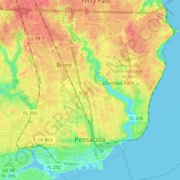
Name: Topografische Karte Pensacola, Höhe, Relief.

Ort: Pensacola, Escambia County, Florida, United States (30.39554 -87.25889 30.51049 -87.14972)

Durchschnittliche Höhe: 21 m

Minimale Höhe: -3 m

Maximale Höhe: 46 m

👉 Easily get elevation data in JSON, GeoTIFF and KML formats using Elevation API
Vielen Dank für die Unterstützung dieser Website ❤️
Spenden

Andere topografische Karten

Klicken Sie auf eine Karte, um ihre Topografie, ihre Höhe und ihr Relief anzuzeigen.

Cantonment

United States > Florida > Escambia County

Durchschnittliche Höhe: 38 m

Beulah

United States > Florida > Escambia County

Durchschnittliche Höhe: 29 m

Walnut Hill

United States > Florida > Escambia County

Durchschnittliche Höhe: 74 m

Pensacola Beach

United States > Florida > Escambia County

Durchschnittliche Höhe: 0 m

Vielen Dank für die Unterstützung dieser Website ❤️
Spenden

Rüsten Sie sich für Ihr nächstes Abenteuer:

Als Amazon-Partner erhält diese Website eine Provision für qualifizierte Käufe, ohne zusätzliche Kosten für Sie.

Pleasant Grove

United States > Florida > Escambia County

Durchschnittliche Höhe: 8 m

Millview

United States > Florida > Escambia County

Durchschnittliche Höhe: 2 m

Sanders Beach

United States > Florida > Escambia County > Pensacola

Durchschnittliche Höhe: 5 m

Beach Haven

United States > Florida > Escambia County

Durchschnittliche Höhe: 8 m

Vielen Dank für die Unterstützung dieser Website ❤️
Spenden

Pensacola Beach

United States > Florida > Escambia County

Durchschnittliche Höhe: 0 m

Navy Point

United States > Florida > Escambia County

Durchschnittliche Höhe: 8 m

Bohemia

United States > Florida > Escambia County > Pensacola

Durchschnittliche Höhe: 15 m

Molino

United States > Florida > Escambia County

Durchschnittliche Höhe: 26 m

Gull Point

United States > Florida > Escambia County > Pensacola

Durchschnittliche Höhe: 10 m

Gull Point

United States > Florida > Escambia County > Pensacola

Durchschnittliche Höhe: 10 m

Myrtle Grove

United States > Florida > Escambia County > Myrtle Grove

Durchschnittliche Höhe: 13 m

Walnut Hill

United States > Florida > Escambia County

Durchschnittliche Höhe: 74 m

Ferry Pass

United States > Florida > Escambia County

Durchschnittliche Höhe: 29 m

Rüsten Sie sich für Ihr nächstes Abenteuer:

🗺️Topographische Karten Deutschland - Detaillierte topographische Karten für Outdoor‑Abenteuer
📦Outdoor Erste Hilfe Set - Notfallset für Wanderungen und Expeditionen
👕Funktionsshirt fürs Wandern - Atmungsaktives Shirt für Outdoor
🎒Outdoor Taschenlampe Set - Set mit Extra Batterien
🧠Outdoor Führer Bücher - Reiseführer und Wanderführer Deutschland

Als Amazon-Partner erhält diese Website eine Provision für qualifizierte Käufe, ohne zusätzliche Kosten für Sie.