
Topografische Karte Morant Bay
Interaktive Karte
Klicken Sie auf die Karte, um die Höhe anzuzeigen.
Über diese Karte
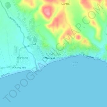
Name: Topografische Karte Morant Bay, Höhe, Relief.
Ort: Morant Bay, Saint Thomas, Surrey County, Jamaica (17.86208 -76.43155 17.90208 -76.39155)
Durchschnittliche Höhe: 23 m
Minimale Höhe: -2 m
Maximale Höhe: 115 m
Andere topografische Karten
Klicken Sie auf eine Karte, um ihre Topografie, ihre Höhe und ihr Relief anzuzeigen.
Suffolk Park
Suffolk Park, Rowlandsfield, Saint Thomas, Surrey County, Jamaica
Durchschnittliche Höhe: 145 m
River Head
River Head, Saint Thomas, Surrey County, Jamaica
Durchschnittliche Höhe: 473 m
York
York, Seaforth, Saint Thomas, Surrey County, Jamaica
Durchschnittliche Höhe: 120 m
Farm Hill
Farm Hill, Saint Thomas, Surrey County, Jamaica
Durchschnittliche Höhe: 1.022 m
Eleven Mile
Eleven Mile, Saint Thomas, Surrey County, Jamaica
Durchschnittliche Höhe: 133 m