
Topografische Karte Cleveland
Interaktive Karte
Klicken Sie auf die Karte, um die Höhe anzuzeigen.
Über diese Karte
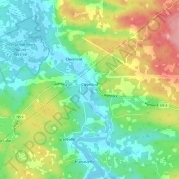
Name: Topografische Karte Cleveland, Höhe, Relief.
Durchschnittliche Höhe: 40 m
Minimale Höhe: -2 m
Maximale Höhe: 115 m
Andere topografische Karten
Klicken Sie auf eine Karte, um ihre Topografie, ihre Höhe und ihr Relief anzuzeigen.
Balmoral
Canada > Nova Scotia > Municipality of the County of Richmond
Balmoral, Grande Anse, Municipality of the County of Richmond, Richmond County, Nova Scotia, B0E 3K0, Canada
Durchschnittliche Höhe: 55 m
Flat Rock
Canada > Nova Scotia > Municipality of the County of Richmond > Grand River
Flat Rock, Grand River, Municipality of the County of Richmond, Richmond County, Nova Scotia, Canada
Durchschnittliche Höhe: 5 m
Point Michaud
Canada > Nova Scotia > Municipality of the County of Richmond
Point Michaud, Municipality of the County of Richmond, Richmond County, Nova Scotia, Canada
Durchschnittliche Höhe: 12 m
Louisdale
Canada > Nova Scotia > Municipality of the County of Richmond
Louisdale, Municipality of the County of Richmond, Richmond County, Nova Scotia, B0E 1V0, Canada
Durchschnittliche Höhe: 26 m