
Topografische Karte Rapid Creek
Interaktive Karte
Klicken Sie auf die Karte, um die Höhe anzuzeigen.
Über diese Karte
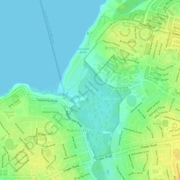
Name: Topografische Karte Rapid Creek, Höhe, Relief.
Durchschnittliche Höhe: 12 m
Minimale Höhe: 0 m
Maximale Höhe: 28 m
Andere topografische Karten
Klicken Sie auf eine Karte, um ihre Topografie, ihre Höhe und ihr Relief anzuzeigen.
Fannie Bay
Australia > City of Darwin > Darwin
Fannie Bay, Darwin, City of Darwin, Northern Territory, 0800, Australia
Durchschnittliche Höhe: 9 m
Casuarina
Australia > City of Darwin > Darwin
Casuarina, Darwin, City of Darwin, Northern Territory, 0800, Australia
Durchschnittliche Höhe: 25 m
Berrimah
Australia > City of Darwin > Darwin
Berrimah, Darwin, City of Darwin, Northern Territory, 0800, Australia
Durchschnittliche Höhe: 30 m
Parap
Australia > City of Darwin > Darwin
Parap, Darwin, City of Darwin, Northern Territory, 0800, Australia
Durchschnittliche Höhe: 15 m
Darwin City
Australia > City of Darwin > Darwin
Darwin City, Darwin, City of Darwin, Northern Territory, 0800, Australia
Durchschnittliche Höhe: 9 m
Stuart Park
Australia > City of Darwin > Darwin
Stuart Park, Darwin, City of Darwin, Northern Territory, 0800, Australia
Durchschnittliche Höhe: 14 m