
Topografische Karte Sivakasi
Klicken Sie auf die Karte, um die Höhe anzuzeigen.
Sivakasi
Sivakasi is located at 9°27′00″N 77°49′00″E / 9.45°N 77.8167°E / 9.45; 77.8167 and has an average elevation of 101 metres (331 feet). The city is located in Virudhunagar district of the South Indian state, Tamil Nadu, at a distance of 74 km (46 mi) from Madurai. Sivakasi is located to the east of Western Ghats and to the west of Sattur. The topography is almost plain, with no major geological formation. There are no notable mineral resources available in and around the city. The soil types are black and red that are conducive to cotton, chillies, and millets. These crops are predominant because of poor groundwater supply and soil type. Sivakasi experiences hot and dry weather throughout the year. The temperature ranges from a maximum of 39 °C (102 °F) to a minimum of 23 °C (73 °F). Like the rest of the state, April to June are the hottest months and December to January are the coldest. Sivakasi receives scanty rainfall with an average of 812 mm (32.0 in) annually, which is lesser than the state average of 1,008 mm (39.7 in). The Southwest monsoon, with an onset in June and lasting up to August, brings scanty rainfall. The bulk of the rainfall is received during the North East monsoon in the months of October, November and December. The average humidity of the city is 76.2% and varies between 65.6% to 79.2%. The municipality covers an area of 6.8 km2 (6,800,000 m2).
Über diese Karte
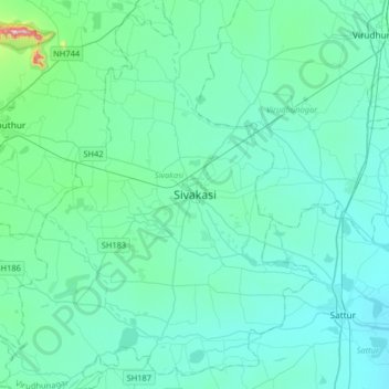
Name: Topografische Karte Sivakasi, Höhe, Relief.
Ort: Sivakasi, Virudhunagar, Tamil Nadu, 626123, India (9.29083 77.63767 9.61083 77.95767)
Durchschnittliche Höhe: 104 m
Minimale Höhe: 55 m
Maximale Höhe: 526 m