
Topografische Karte Forth and Clyde Canal
Interaktive Karte
Klicken Sie auf die Karte, um die Höhe anzuzeigen.
Über diese Karte
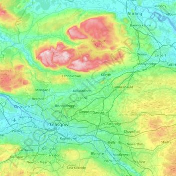
Name: Topografische Karte Forth and Clyde Canal, Höhe, Relief.
Durchschnittliche Höhe: 130 m
Minimale Höhe: -3 m
Maximale Höhe: 569 m
Andere topografische Karten
Klicken Sie auf eine Karte, um ihre Topografie, ihre Höhe und ihr Relief anzuzeigen.
Fort William
VK > Schotland > Fort William
Fort William, Highland, Schotland, PH33 6DH, VK
Durchschnittliche Höhe: 122 m
Caledonian Canal
Caledonian Canal, Highland, Schotland, IV3 8RE, VK
Durchschnittliche Höhe: 420 m
Linga
VK > Schotland > South Garth
Linga, South Garth, Shetland Islands, Schotland, VK
Durchschnittliche Höhe: 7 m
Greenbraehead
VK > Schotland > Greenbraehead
Greenbraehead, Scottish Borders, Schotland, TD9 9SW, VK
Durchschnittliche Höhe: 187 m
Union Canal
Union Canal, West Lothian, Schotland, EH11 1AS, VK
Durchschnittliche Höhe: 136 m