
Topografische Karte Cāchār
Interaktive Karte
Klicken Sie auf die Karte, um die Höhe anzuzeigen.
Über diese Karte
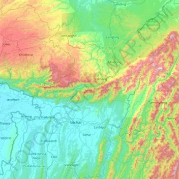
Name: Topografische Karte Cāchār, Höhe, Relief.
Ort: Cāchār, Dima Hasao district, Assam, India (24.38333 92.21667 25.78333 93.61667)
Durchschnittliche Höhe: 476 m
Minimale Höhe: 9 m
Maximale Höhe: 2.141 m
Andere topografische Karten
Klicken Sie auf eine Karte, um ihre Topografie, ihre Höhe und ihr Relief anzuzeigen.
Namrup
India > Assam > Naharkatiya
Namrup, Naharkatiya, Dibrugarh District, Assam, 786623, India
Durchschnittliche Höhe: 133 m
North Lakhimpur
North Lakhimpur, Lakhimpur District, Assam, India
Durchschnittliche Höhe: 96 m
Karbi Anglong
Karbi Anglong, East Karbi Anglong, Assam, India
Durchschnittliche Höhe: 437 m
South Salmara
South Salmara, South Salmara-Mankachar, Assam, India
Durchschnittliche Höhe: 40 m
Udalguri
India > Assam > Udalguri tehsil
Udalguri, Udalguri tehsil, Udalguri district, Assam, 784509, India
Durchschnittliche Höhe: 109 m
Jorhat
India > Assam > Jorhat East
Jorhat, Jorhat East, Jorhat District, Assam, 785001, India
Durchschnittliche Höhe: 93 m
Umiam River
Umiam River, Donka, West Karbi Anglong, Assam, India
Durchschnittliche Höhe: 456 m