Geolokalisieren

Topografische Karte Burnhaupt-le-Haut

Interaktive Karte

Klicken Sie auf die Karte, um die Höhe anzuzeigen.

Über diese Karte

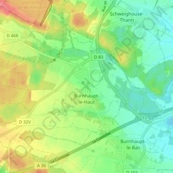
Name: Topografische Karte Burnhaupt-le-Haut, Höhe, Relief.

Ort: Burnhaupt-le-Haut, Thann-Guebwiller, Haut-Rhin, Grand Est, Metropolitan France, 68520, France (47.71860 7.09442 47.75133 7.16263)

Durchschnittliche Höhe: 308 m

Minimale Höhe: 279 m

Maximale Höhe: 354 m

Andere topografische Karten

Klicken Sie auf eine Karte, um ihre Topografie, ihre Höhe und ihr Relief anzuzeigen.

Lauw

France > Grand Est > Haut-Rhin

Lauw, Thann-Guebwiller, Haut-Rhin, Grand Est, Metropolitan France, 68290, France

Durchschnittliche Höhe: 444 m

Durmenach

France > Grand Est > Haut-Rhin

Durmenach, Altkirch, Haut-Rhin, Grand Est, Metropolitan France, 68480, France

Durchschnittliche Höhe: 409 m

Le Bonhomme

France > Grand Est > Haut-Rhin

Le Bonhomme, Colmar-Ribeauvillé, Haut-Rhin, Grand Est, Metropolitan France, 68650, France

Durchschnittliche Höhe: 904 m

Husseren-les-Châteaux

France > Grand Est > Haut-Rhin

Husseren-les-Châteaux, Colmar-Ribeauvillé, Haut-Rhin, Grand Est, Metropolitan France, 68420, France

Durchschnittliche Höhe: 398 m

Orbey

France > Grand Est > Haut-Rhin > Orbey

Orbey, Colmar-Ribeauvillé, Haut-Rhin, Grand Est, Metropolitan France, 68370, France

Durchschnittliche Höhe: 730 m

Mittlach

France > Grand Est > Haut-Rhin > Mittlach

Mittlach, Colmar-Ribeauvillé, Haut-Rhin, Grand Est, Metropolitan France, 68380, France

Durchschnittliche Höhe: 862 m

Oderen

France > Grand Est > Haut-Rhin > Oderen

Oderen, Thann-Guebwiller, Haut-Rhin, Grand Est, Metropolitan France, 68830, France

Durchschnittliche Höhe: 822 m