Geolokalisieren

Topografische Karte Leeds and Grenville

Interaktive Karte

Klicken Sie auf die Karte, um die Höhe anzuzeigen.

Über diese Karte

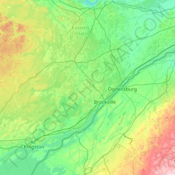
Name: Topografische Karte Leeds and Grenville, Höhe, Relief.

Ort: Leeds and Grenville, Leeds and Grenville Counties, Eastern Ontario, Ontario, Canada (43.99923 -76.57580 45.39923 -75.17580)

Durchschnittliche Höhe: 146 m

Minimale Höhe: 50 m

Maximale Höhe: 704 m

Andere topografische Karten

Klicken Sie auf eine Karte, um ihre Topografie, ihre Höhe und ihr Relief anzuzeigen.

Kemptville

Canada > Ontario > Leeds and Grenville Counties > North Grenville

Kemptville, North Grenville, Leeds and Grenville Counties, Eastern Ontario, Ontario, K0G 1J0, Canada

Durchschnittliche Höhe: 97 m