
Topografische Karte Moorhead
Interaktive Karte
Klicken Sie auf die Karte, um die Höhe anzuzeigen.
Über diese Karte
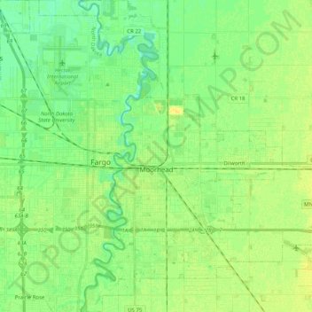
Name: Topografische Karte Moorhead, Höhe, Relief.
Ort: Moorhead, Clay County, Minnesota, United States (46.81103 -96.80044 46.94860 -96.64777)
Durchschnittliche Höhe: 277 m
Minimale Höhe: 268 m
Maximale Höhe: 285 m
Andere topografische Karten
Klicken Sie auf eine Karte, um ihre Topografie, ihre Höhe und ihr Relief anzuzeigen.
Dilworth
United States > Minnesota > Clay County
Dilworth, Clay County, Minnesota, 56529, United States
Durchschnittliche Höhe: 278 m
Comstock
United States > Minnesota > Clay County
Comstock, Clay County, Minnesota, 56525, United States
Durchschnittliche Höhe: 281 m
Hitterdal
United States > Minnesota > Clay County
Hitterdal, Clay County, Minnesota, United States
Durchschnittliche Höhe: 379 m
Georgetown
United States > Minnesota > Clay County
Georgetown, Clay County, Minnesota, United States
Durchschnittliche Höhe: 269 m
Baker
United States > Minnesota > Clay County
Baker, Clay County, Minnesota, United States
Durchschnittliche Höhe: 286 m
Hitterdahl WMA
United States > Minnesota > Clay County
Hitterdahl WMA, 270th Street North, Clay County, Minnesota, 56552, United States
Durchschnittliche Höhe: 379 m
Sabin
United States > Minnesota > Clay County
Sabin, Clay County, Minnesota, United States
Durchschnittliche Höhe: 282 m
Glyndon
United States > Minnesota > Clay County
Glyndon, Clay County, Minnesota, 56547, United States
Durchschnittliche Höhe: 282 m
Kragnes
United States > Minnesota > Clay County
Kragnes, Clay County, Minnesota, United States
Durchschnittliche Höhe: 273 m
Ulen
United States > Minnesota > Clay County
Ulen, Clay County, Minnesota, 56585, United States
Durchschnittliche Höhe: 352 m
Moorhead
United States > Minnesota > Clay County > Moorhead > Moorhead
Moorhead, Clay County, Minnesota, 56563, United States
Durchschnittliche Höhe: 277 m
confluence of Red River of the North and Buffalo River
United States > Minnesota > Clay County
confluence of Red River of the North and Buffalo River, Wiser Township, Clay County, Minnesota, United States
Durchschnittliche Höhe: 268 m
Barnesville
United States > Minnesota > Clay County
Barnesville, Clay County, Minnesota, 56514, United States
Durchschnittliche Höhe: 311 m
Felton
United States > Minnesota > Clay County
Felton, Clay County, Minnesota, United States
Durchschnittliche Höhe: 279 m
Hawley
United States > Minnesota > Clay County
Hawley, Clay County, Minnesota, United States
Durchschnittliche Höhe: 356 m