
Topografische Karte Bennett
Interaktive Karte
Klicken Sie auf die Karte, um die Höhe anzuzeigen.
Über diese Karte
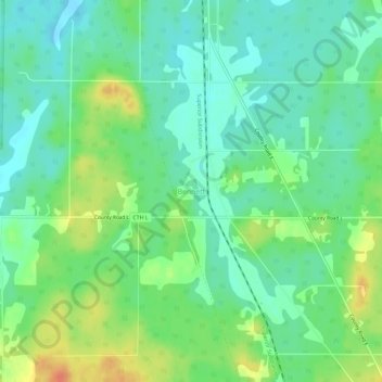
Name: Topografische Karte Bennett, Höhe, Relief.
Durchschnittliche Höhe: 368 m
Minimale Höhe: 352 m
Maximale Höhe: 398 m
Andere topografische Karten
Klicken Sie auf eine Karte, um ihre Topografie, ihre Höhe und ihr Relief anzuzeigen.
City of Superior
United States > Wisconsin > Douglas County
City of Superior, Douglas County, Wisconsin, 54880, United States
Durchschnittliche Höhe: 220 m
Solon Springs
United States > Wisconsin > Douglas County
Solon Springs, Douglas County, Wisconsin, United States
Durchschnittliche Höhe: 334 m
Oliver
United States > Wisconsin > Douglas County
Oliver, Douglas County, Wisconsin, United States
Durchschnittliche Höhe: 207 m
Lake Nebagamon
United States > Wisconsin > Douglas County
Lake Nebagamon, Douglas County, Wisconsin, 54849, United States
Durchschnittliche Höhe: 351 m
Dairyland
United States > Wisconsin > Douglas County
Dairyland, Town of Dairyland, Douglas County, Wisconsin, United States
Durchschnittliche Höhe: 339 m
Town of Maple
United States > Wisconsin > Douglas County
Town of Maple, Douglas County, Wisconsin, 54854, United States
Durchschnittliche Höhe: 302 m
Big Manitou Falls
United States > Wisconsin > Douglas County > Town of Superior
Big Manitou Falls, Town of Superior, Douglas County, Wisconsin, United States
Durchschnittliche Höhe: 295 m
Town of Brule
United States > Wisconsin > Douglas County
Town of Brule, Douglas County, Wisconsin, 54820, United States
Durchschnittliche Höhe: 327 m
South Range
United States > Wisconsin > Douglas County
South Range, Town of Parkland, Douglas County, Wisconsin, 54874, United States
Durchschnittliche Höhe: 237 m
Foxboro
United States > Wisconsin > Douglas County
Foxboro, Town of Summit, Douglas County, Wisconsin, United States
Durchschnittliche Höhe: 277 m
Poplar
United States > Wisconsin > Douglas County
Poplar, Douglas County, Wisconsin, 54864, United States
Durchschnittliche Höhe: 305 m