
Spenden
Rüsten Sie sich für Ihr nächstes Abenteuer:
Als Amazon-Partner erhält diese Website eine Provision für qualifizierte Käufe, ohne zusätzliche Kosten für Sie.
Topografische Karte Glascock Mountain
Klicken Sie auf die Karte, um die Höhe anzuzeigen.
Spenden
Rüsten Sie sich für Ihr nächstes Abenteuer:
Als Amazon-Partner erhält diese Website eine Provision für qualifizierte Käufe, ohne zusätzliche Kosten für Sie.
Über diese Karte
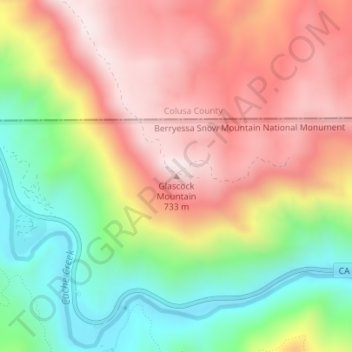
Name: Topografische Karte Glascock Mountain, Höhe, Relief.
Ort: Glascock Mountain, Yolo County, California, United States (38.91985 -122.30364 38.91995 -122.30354)
Durchschnittliche Höhe: 477 m
Minimale Höhe: 159 m
Maximale Höhe: 771 m
Spenden
Rüsten Sie sich für Ihr nächstes Abenteuer:
Als Amazon-Partner erhält diese Website eine Provision für qualifizierte Käufe, ohne zusätzliche Kosten für Sie.
Andere topografische Karten
Klicken Sie auf eine Karte, um ihre Topografie, ihre Höhe und ihr Relief anzuzeigen.
Davis
United States > California > Yolo County
Davis lies in the Sacramento Valley, the northern portion of the Central Valley, in Northern California, at an elevation of about 52 feet (16 m) above sea level.
Durchschnittliche Höhe: 14 m
Spenden
Rüsten Sie sich für Ihr nächstes Abenteuer:
Als Amazon-Partner erhält diese Website eine Provision für qualifizierte Käufe, ohne zusätzliche Kosten für Sie.
Guinda
United States > California > Yolo County
Guinda (Spanish for "Sour cherry") is a census-designated place in Yolo County, California. It is located in the Capay Valley, in the northwestern portion of the county, 13 miles (21 km) northwest of Esparto. Guinda's ZIP Code is 95637 and the town is in area code 530. It lies at an elevation of 361 feet (110…
Durchschnittliche Höhe: 124 m
Davis
United States > California > Yolo County
Davis lies in the Sacramento Valley, the northern portion of the Central Valley, in Northern California, at an elevation of about 52 feet (16 m) above sea level.
Durchschnittliche Höhe: 14 m
Spenden
Rüsten Sie sich für Ihr nächstes Abenteuer:
Als Amazon-Partner erhält diese Website eine Provision für qualifizierte Käufe, ohne zusätzliche Kosten für Sie.
Rumsey
United States > California > Yolo County
Rumsey is an unincorporated community and census-designated place (CDP) in Yolo County, California. It is located 18 miles (29 km) northwest of Esparto, in the Capay Valley, in the northwestern part of the county. Rumsey's ZIP Code is 95679 and its area code 530. It lies at an elevation of 420 feet (128 m).
Durchschnittliche Höhe: 194 m
Davis
United States > California > Yolo County
Davis lies in the Sacramento Valley, the northern portion of the Central Valley, in Northern California, at an elevation of about 52 feet (16 m) above sea level.
Durchschnittliche Höhe: 14 m