Geolokalisieren

Topografische Karte Ham-sur-Meuse

Interaktive Karte

Klicken Sie auf die Karte, um die Höhe anzuzeigen.

Über diese Karte

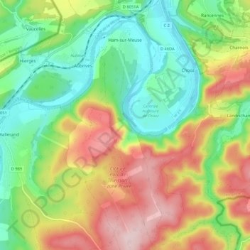
Name: Topografische Karte Ham-sur-Meuse, Höhe, Relief.

Ort: Ham-sur-Meuse, Charleville-Mézières, Ardennes, Grand Est, France métropolitaine, 08600, France (50.05307 4.76693 50.12092 4.80121)

Durchschnittliche Höhe: 205 m

Minimale Höhe: 96 m

Maximale Höhe: 358 m

Andere topografische Karten

Klicken Sie auf eine Karte, um ihre Topografie, ihre Höhe und ihr Relief anzuzeigen.

Quilly

France > Grand Est > Ardennes

Quilly, Vouziers, Ardennes, Grand Est, France métropolitaine, 08400, France

Durchschnittliche Höhe: 136 m

Son

France > Grand Est > Ardennes

Son, Rethel, Ardennes, Grand Est, France métropolitaine, 08300, France

Durchschnittliche Höhe: 121 m

Forrière

France > Grand Est > Ardennes > This

Forrière, This, Charleville-Mézières, Ardennes, Grand Est, France métropolitaine, 08090, France

Durchschnittliche Höhe: 222 m

Saint-Laurent

France > Grand Est > Ardennes

Saint-Laurent, Charleville-Mézières, Ardennes, Grand Est, France métropolitaine, 08090, France

Durchschnittliche Höhe: 204 m

Aire

France > Grand Est > Ardennes

Aire, Rethel, Ardennes, Grand Est, France métropolitaine, 08190, France

Durchschnittliche Höhe: 94 m

Tannay

France > Grand Est > Ardennes

Tannay, Vouziers, Ardennes, Grand Est, France métropolitaine, 08390, France

Durchschnittliche Höhe: 189 m

Gruyères

France > Grand Est > Ardennes

Gruyères, Charleville-Mézières, Ardennes, Grand Est, France métropolitaine, 08430, France

Durchschnittliche Höhe: 259 m

Moiry

France > Grand Est > Ardennes

Moiry, Sedan, Ardennes, Grand Est, France métropolitaine, 08370, France

Durchschnittliche Höhe: 210 m