
Topografische Karte Lac Noir
Interaktive Karte
Klicken Sie auf die Karte, um die Höhe anzuzeigen.
Über diese Karte
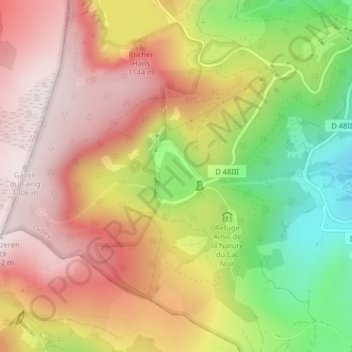
Name: Topografische Karte Lac Noir, Höhe, Relief.
Durchschnittliche Höhe: 1.052 m
Minimale Höhe: 730 m
Maximale Höhe: 1.297 m
Le lac Noir est un lac glaciaire situé sous la crête du versant est du massif des Vosges vers 935 mètres d’altitude moyenne, sous le col du Louchbach, en amont d'Orbey. Il est établi dans un cirque glaciaire de hautes falaises granitiques, naturellement barré par un cordon morainique ; son émissaire est le « ruisseau du lac Noir » qui rejoint la Weiss en aval d’Orbey. Le lac Blanc, analogue mais environ trois fois plus étendu et deux fois plus profond, est situé à environ un kilomètre en amont de lui, vers 1 050 mètres d’altitude moyenne. Les deux cirques sont séparés par l’arête granitique du Reisberg qui culmine à 1 272 mètres.
Andere topografische Karten
Klicken Sie auf eine Karte, um ihre Topografie, ihre Höhe und ihr Relief anzuzeigen.
Les Basses Huttes
France > Grand Est > Haut-Rhin > Orbey
Les Basses Huttes, Orbey, Colmar-Ribeauvillé, Haut-Rhin, Grand Est, France métropolitaine, 68370, France
Durchschnittliche Höhe: 809 m
Tête des Faux
France > Grand Est > Haut-Rhin > Orbey
Tête des Faux, Orbey, Colmar-Ribeauvillé, Haut-Rhin, Grand Est, France métropolitaine, 68370, France
Durchschnittliche Höhe: 994 m
Les Hautes-Huttes
France > Grand Est > Haut-Rhin > Orbey
Les Hautes-Huttes, Orbey, Colmar-Ribeauvillé, Haut-Rhin, Grand Est, France métropolitaine, 68370, France
Durchschnittliche Höhe: 868 m
Auberge-Refuge Le Blancrupt
France > Grand Est > Haut-Rhin > Orbey
Auberge-Refuge Le Blancrupt, D 48II, Orbey, Colmar-Ribeauvillé, Haut-Rhin, Grand Est, France métropolitaine, 68370, France
Durchschnittliche Höhe: 1.080 m