
Topografische Karte Red Hill Fire Tower
Interaktive Karte
Klicken Sie auf die Karte, um die Höhe anzuzeigen.
Über diese Karte
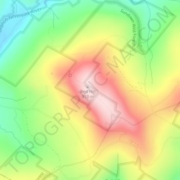
Name: Topografische Karte Red Hill Fire Tower, Höhe, Relief.
Durchschnittliche Höhe: 713 m
Minimale Höhe: 537 m
Maximale Höhe: 906 m
The cabin is a small, one-story, 14-by-24-foot (4.3 by 7.3 m) gable-roofed frame building. It is sided with "brainstorm", edge board stained reddish brown. It has a mortared rubblestone foundation and a covered porch on the south elevation, originally decked in wood but since replaced with concrete. Built in 1931, it is one of the oldest remaining observer's cabins in New York, a rare intact example of the earlier style used by the then-state Conservation Commission.
Andere topografische Karten
Klicken Sie auf eine Karte, um ihre Topografie, ihre Höhe und ihr Relief anzuzeigen.
Frost Valley
United States > New York > Ulster County > Town of Denning > Frost Valley
Frost Valley, Town of Denning, Ulster County, New York, United States
Durchschnittliche Höhe: 735 m