
Spenden
Rüsten Sie sich für Ihr nächstes Abenteuer:
Als Amazon-Partner erhält diese Website eine Provision für qualifizierte Käufe, ohne zusätzliche Kosten für Sie.
Topografische Karte Kallin
Klicken Sie auf die Karte, um die Höhe anzuzeigen.
Spenden
Rüsten Sie sich für Ihr nächstes Abenteuer:
Als Amazon-Partner erhält diese Website eine Provision für qualifizierte Käufe, ohne zusätzliche Kosten für Sie.
Über diese Karte
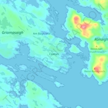
Name: Topografische Karte Kallin, Höhe, Relief.
Ort: Kallin, Western Isles, Scotland, HS6 5HY, United Kingdom (57.46033 -7.23255 57.50033 -7.19255)
Durchschnittliche Höhe: 10 m
Minimale Höhe: -2 m
Maximale Höhe: 108 m
Spenden
Rüsten Sie sich für Ihr nächstes Abenteuer:
Als Amazon-Partner erhält diese Website eine Provision für qualifizierte Käufe, ohne zusätzliche Kosten für Sie.
Andere topografische Karten
Klicken Sie auf eine Karte, um ihre Topografie, ihre Höhe und ihr Relief anzuzeigen.
Barra
United Kingdom > Scotland > Western Isles > Brevig
The highest elevation on the island is Heaval, near the top of which is a prominent white marble statue of the Madonna and Child, called "Our Lady of the Sea", which was erected during the Marian year of 1954. The predominant faith on the island is Catholicism and the Catholic church dedicated to Our Lady of…
Durchschnittliche Höhe: 27 m
Spenden
Rüsten Sie sich für Ihr nächstes Abenteuer:
Als Amazon-Partner erhält diese Website eine Provision für qualifizierte Käufe, ohne zusätzliche Kosten für Sie.
South Uist
United Kingdom > Scotland > Western Isles
In the north west of the island at (57°20′N 07°20′W / 57.333°N 7.333°W / 57.333; -7.333), a missile testing range was built in 1957–58 to launch the Corporal missile, Britain and America's first guided nuclear weapon. This development went ahead despite significant protests, some locals…
Durchschnittliche Höhe: 15 m
Benbecula
United Kingdom > Scotland > Western Isles > Nunton
There is a dense cluster of lochs across almost the entire island, and almost the whole island is below 20 metres (70 feet) in elevation.
Durchschnittliche Höhe: 5 m
Spenden
Rüsten Sie sich für Ihr nächstes Abenteuer:
Als Amazon-Partner erhält diese Website eine Provision für qualifizierte Käufe, ohne zusätzliche Kosten für Sie.
North Rona
United Kingdom > Scotland > Western Isles
Rona (Scottish Gaelic: Rònaigh) is an uninhabited Scottish island in the North Atlantic. It is often referred to as North Rona to distinguish it from the island of South Rona in the Inner Hebrides. It has an area of 109 hectares (270 acres) and a maximum elevation of 108 metres (354 ft).
Durchschnittliche Höhe: 4 m
Spenden
Rüsten Sie sich für Ihr nächstes Abenteuer:
Als Amazon-Partner erhält diese Website eine Provision für qualifizierte Käufe, ohne zusätzliche Kosten für Sie.
Spenden
Rüsten Sie sich für Ihr nächstes Abenteuer:
Als Amazon-Partner erhält diese Website eine Provision für qualifizierte Käufe, ohne zusätzliche Kosten für Sie.
Spenden
Rüsten Sie sich für Ihr nächstes Abenteuer:
Als Amazon-Partner erhält diese Website eine Provision für qualifizierte Käufe, ohne zusätzliche Kosten für Sie.
Barra
United Kingdom > Scotland > Western Isles > Borve
The highest elevation on the island is Heaval, near the top of which is a prominent white marble statue of the Madonna and Child, called "Our Lady of the Sea", which was erected during the Marian year of 1954. The predominant faith on the island is Catholicism and the Catholic church dedicated to Our Lady of…
Durchschnittliche Höhe: 27 m
Spenden
Rüsten Sie sich für Ihr nächstes Abenteuer:
Als Amazon-Partner erhält diese Website eine Provision für qualifizierte Käufe, ohne zusätzliche Kosten für Sie.
Spenden
Rüsten Sie sich für Ihr nächstes Abenteuer:
Als Amazon-Partner erhält diese Website eine Provision für qualifizierte Käufe, ohne zusätzliche Kosten für Sie.
Benbecula
United Kingdom > Scotland > Western Isles > Torlum
There is a dense cluster of lochs across almost the entire island, and almost the whole island is below 20 metres (70 feet) in elevation.
Durchschnittliche Höhe: 5 m
Spenden
Rüsten Sie sich für Ihr nächstes Abenteuer:
Als Amazon-Partner erhält diese Website eine Provision für qualifizierte Käufe, ohne zusätzliche Kosten für Sie.
Barra
United Kingdom > Scotland > Western Isles > Borve
The highest elevation on the island is Heaval, near the top of which is a prominent white marble statue of the Madonna and Child, called "Our Lady of the Sea", which was erected during the Marian year of 1954. The predominant faith on the island is Catholicism and the Catholic church dedicated to Our Lady of…
Durchschnittliche Höhe: 27 m
Benbecula
United Kingdom > Scotland > Western Isles > Nunton
There is a dense cluster of lochs across almost the entire island, and almost the whole island is below 20 metres (70 feet) in elevation.
Durchschnittliche Höhe: 5 m