
Topografische Karte Maasmechelen
Interaktive Karte
Klicken Sie auf die Karte, um die Höhe anzuzeigen.
Über diese Karte
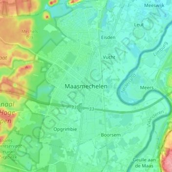
Name: Topografische Karte Maasmechelen, Höhe, Relief.
Durchschnittliche Höhe: 48 m
Minimale Höhe: 29 m
Maximale Höhe: 110 m
The plateau of Campine was built up during the ice age with deposits of sand and other material that the Meuse river had eroded in the upstream Ardennes region. The higher elevation and the proximity of fertile river clay made this location an attractive one for the prehistoric tribes who established themselves here in the 2nd millennium BC and for the Celtic peoples who moved in the area in the 1st millennium BC.