Geolokalisieren
👉 Easily get elevation data in JSON, GeoTIFF and KML formats using Elevation API
Vielen Dank für die Unterstützung dieser Website ❤️
Spenden

Rüsten Sie sich für Ihr nächstes Abenteuer:

Als Amazon-Partner erhält diese Website eine Provision für qualifizierte Käufe, ohne zusätzliche Kosten für Sie.

Topografische Karte Little Straggle Lake

Klicken Sie auf die Karte, um die Höhe anzuzeigen.

Über diese Karte

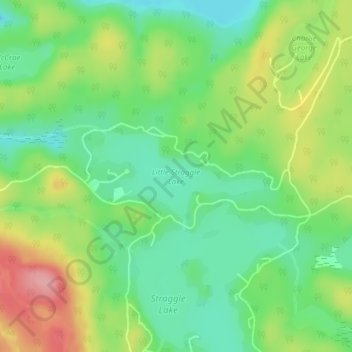
Name: Topografische Karte Little Straggle Lake, Höhe, Relief.

Ort: Little Straggle Lake, Dysart et al, Haliburton County, Central Ontario, Ontario, Canada (45.12240 -78.20938 45.12916 -78.19085)

Durchschnittliche Höhe: 433 m

Minimale Höhe: 386 m

Maximale Höhe: 506 m

👉 Easily get elevation data in JSON, GeoTIFF and KML formats using Elevation API
Vielen Dank für die Unterstützung dieser Website ❤️
Spenden

Rüsten Sie sich für Ihr nächstes Abenteuer:

Als Amazon-Partner erhält diese Website eine Provision für qualifizierte Käufe, ohne zusätzliche Kosten für Sie.

Andere topografische Karten

Klicken Sie auf eine Karte, um ihre Topografie, ihre Höhe und ihr Relief anzuzeigen.

Kashagawigamog Lake

Canada > Ontario > Haliburton County > Dysart et al

Durchschnittliche Höhe: 340 m

Percy Lake

Canada > Ontario > Haliburton County > Dysart et al

Durchschnittliche Höhe: 397 m

Haliburton Lake

Canada > Ontario > Haliburton County > Dysart et al

Durchschnittliche Höhe: 392 m

Benoir Lake

Canada > Ontario > Haliburton County > Dysart et al

Durchschnittliche Höhe: 395 m

Vielen Dank für die Unterstützung dieser Website ❤️
Spenden

Elephant Lake

Canada > Ontario > Haliburton County > Dysart et al

Durchschnittliche Höhe: 395 m

Two Islands Lake

Canada > Ontario > Haliburton County > Dysart et al

Durchschnittliche Höhe: 387 m

Miskwabi Lake

Canada > Ontario > Haliburton County > Dysart et al

Durchschnittliche Höhe: 410 m

Lipsy Lake

Canada > Ontario > Haliburton County > Dysart et al

Durchschnittliche Höhe: 419 m

Grace Lake

Canada > Ontario > Haliburton County > Dysart et al

Durchschnittliche Höhe: 401 m

Redstone Lake

Canada > Ontario > Haliburton County > Dysart et al

Durchschnittliche Höhe: 378 m

Kennaway

Canada > Ontario > Haliburton County > Dysart et al

Durchschnittliche Höhe: 390 m

Kennisis Lake

Canada > Ontario > Haliburton County > Dysart et al

Durchschnittliche Höhe: 403 m

Haliburton

Canada > Ontario > Haliburton County > Dysart et al

Durchschnittliche Höhe: 370 m

Long Lake

Canada > Ontario > Haliburton County > Dysart et al

Durchschnittliche Höhe: 415 m

Fishtail Lake

Canada > Ontario > Haliburton County > Dysart et al

Durchschnittliche Höhe: 427 m

Vielen Dank für die Unterstützung dieser Website ❤️
Spenden

Donald

Canada > Ontario > Haliburton County > Dysart et al

Durchschnittliche Höhe: 356 m

Scorch Lake

Canada > Ontario > Haliburton County > Dysart et al

Durchschnittliche Höhe: 436 m

Drag lake

Canada > Ontario > Haliburton County > Dysart et al > Haliburton

Durchschnittliche Höhe: 394 m

Kennisis Lake

Canada > Ontario > Haliburton County > Dysart et al

Durchschnittliche Höhe: 403 m

Haliburton Lake

Canada > Ontario > Haliburton County > Dysart et al

Durchschnittliche Höhe: 392 m

Haliburton

Canada > Ontario > Haliburton County > Dysart et al

Durchschnittliche Höhe: 370 m

Rüsten Sie sich für Ihr nächstes Abenteuer:

🧤Winddichte Handschuhe - Schutz vor Kälte und Wind bei Gipfelstürmen
🗺️Topographische Karten Deutschland - Detaillierte topographische Karten für Outdoor‑Abenteuer
🔭Nachtsichtgeräte - Beobachtung der Natur nach Sonnenuntergang
🔪Outdoor-Messer - Vielseitige Werkzeuge für Bushcraft und Camping
📊Adventure Buch Tipps - Inspiration & Ratgeber für Outdoor Fans

Als Amazon-Partner erhält diese Website eine Provision für qualifizierte Käufe, ohne zusätzliche Kosten für Sie.