Geolokalisieren

Topografische Karte Marsa Matruh

Interaktive Karte

Klicken Sie auf die Karte, um die Höhe anzuzeigen.

Über diese Karte

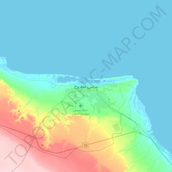
Name: Topografische Karte Marsa Matruh, Höhe, Relief.

Ort: Marsa Matruh, Matruh, 51511, Egypt (31.19286 27.07953 31.51286 27.39953)

Durchschnittliche Höhe: 37 m

Minimale Höhe: -3 m

Maximale Höhe: 182 m

Andere topografische Karten

Klicken Sie auf eine Karte, um ihre Topografie, ihre Höhe und ihr Relief anzuzeigen.

Qattara Depression

Egypt > Matruh

Qattara Depression, Matruh, Egypt

Durchschnittliche Höhe: -75 m

Al Daba‘ a

Egypt > Matruh

Al Daba‘ a, Matruh, Egypt

Durchschnittliche Höhe: 29 m

El Alamein

Egypt > Matruh

El Alamein, Matruh, Egypt

Durchschnittliche Höhe: 19 m

Ras Alem Ghomed

Egypt > Matruh

Ras Alem Ghomed, Matruh, Egypt

Durchschnittliche Höhe: 10 m

Cascada

Egypt > Matruh

Cascada, Matruh, Egypt

Durchschnittliche Höhe: 6 m

مراسي

Egypt > Matruh

مراسي, Matruh, 51732, Egypt

Durchschnittliche Höhe: 7 m

Siwa Oasis

Egypt > Matruh > Siwa Oasis

Siwa Oasis, Matruh, Egypt

Durchschnittliche Höhe: -6 m

Siwa Oasis

Egypt > Matruh

Siwa Oasis, Matruh, Egypt

Durchschnittliche Höhe: 30 m

al maadi

Egypt > Matruh

al maadi, Matruh, Egypt

Durchschnittliche Höhe: 4 m