
Topografische Karte Panton Hill
Interaktive Karte
Klicken Sie auf die Karte, um die Höhe anzuzeigen.
Über diese Karte
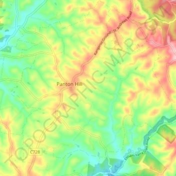
Name: Topografische Karte Panton Hill, Höhe, Relief.
Ort: Panton Hill, Shire of Nillumbik, Victoria, 3759, Australia (-37.67124 145.21507 -37.61422 145.28610)
Durchschnittliche Höhe: 152 m
Minimale Höhe: 77 m
Maximale Höhe: 249 m
Andere topografische Karten
Klicken Sie auf eine Karte, um ihre Topografie, ihre Höhe und ihr Relief anzuzeigen.
Panton Hill
Australia > Victoria > Panton Hill
Panton Hill, Shire of Nillumbik, Victoria, 3759, Australia
Durchschnittliche Höhe: 150 m
Cottles Bridge
Australia > Victoria > Panton Hill
Cottles Bridge, Panton Hill, Shire of Nillumbik, Victoria, Australia
Durchschnittliche Höhe: 143 m