
Spenden
Rüsten Sie sich für Ihr nächstes Abenteuer:
Als Amazon-Partner erhält diese Website eine Provision für qualifizierte Käufe, ohne zusätzliche Kosten für Sie.
Topografische Karte General Tinio
Klicken Sie auf die Karte, um die Höhe anzuzeigen.
Spenden
Rüsten Sie sich für Ihr nächstes Abenteuer:
Als Amazon-Partner erhält diese Website eine Provision für qualifizierte Käufe, ohne zusätzliche Kosten für Sie.
General Tinio
Farming is the livelihood of majority of the residents. Even though located at the foot of the Sierra Madre Mountain Ridges, the topography is generally plain ideal to agricultural products such as palay and vegetables. A number of poultry broiler contract growers are located in the municipality. Other industries include furniture and fixtures, backyard poultry, cattle and livestock, vegetable production and minor agricultural livelihoods like duck raising. "Ikmo" or betel leaves production is one dying symbol of the town. The practice of chewing betel leaves by the older generation was not adopted by the younger generation even though of its reported natural anti-cancer formula.
Spenden
Rüsten Sie sich für Ihr nächstes Abenteuer:
Als Amazon-Partner erhält diese Website eine Provision für qualifizierte Käufe, ohne zusätzliche Kosten für Sie.
Über diese Karte
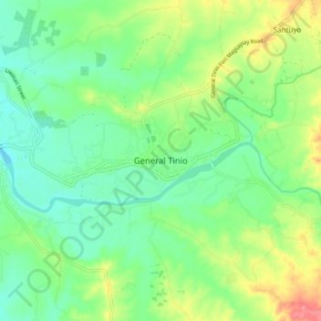
Name: Topografische Karte General Tinio, Höhe, Relief.
Ort: General Tinio, Nueva Ecija, Central Luzon, 3104, Philippines (15.31013 121.00980 15.39013 121.08980)
Durchschnittliche Höhe: 54 m
Minimale Höhe: 28 m
Maximale Höhe: 104 m
Spenden
Rüsten Sie sich für Ihr nächstes Abenteuer:
Als Amazon-Partner erhält diese Website eine Provision für qualifizierte Käufe, ohne zusätzliche Kosten für Sie.
Andere topografische Karten
Klicken Sie auf eine Karte, um ihre Topografie, ihre Höhe und ihr Relief anzuzeigen.
Talavera
The municipality's terrain is relatively flat, with slope ranging from 0 to 3%. Due to the flat topography, the land is suited for agricultural, commercial or industrial development. It is bordered by Cabanatuan, Llanera, Muñoz, Aliaga, General Mamerto Natividad, Santo Domingo and San Jose.
Durchschnittliche Höhe: 49 m
Spenden
Rüsten Sie sich für Ihr nächstes Abenteuer:
Als Amazon-Partner erhält diese Website eine Provision für qualifizierte Käufe, ohne zusätzliche Kosten für Sie.