
Topografische Karte Charouine
Interaktive Karte
Klicken Sie auf die Karte, um die Höhe anzuzeigen.
Charouine
Charouine lies at an elevation of 285 metres (935 ft) near an oasis, part of the Gourara region of northern Adrar Province. Groves of trees are found around the main town; to the north-west the terrain is dominated by rocky areas and sand dunes, while to the south-east near the village of Taguelzi the terrain falls away dramatically, featuring cliffs up to 50 metres (160 ft) high.
Über diese Karte
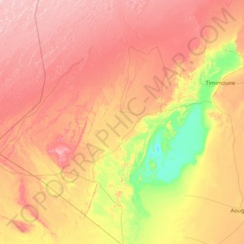
Name: Topografische Karte Charouine, Höhe, Relief.
Durchschnittliche Höhe: 312 m
Minimale Höhe: 170 m
Maximale Höhe: 471 m