Geolokalisieren

Topografische Karte Teynham

Klicken Sie auf die Karte, um die Höhe anzuzeigen.

👉 Easily get elevation data in JSON, GeoTIFF and KML formats using Elevation API
Vielen Dank für die Unterstützung dieser Website ❤️
Spenden

Rüsten Sie sich für Ihr nächstes Abenteuer:

Als Amazon-Partner erhält diese Website eine Provision für qualifizierte Käufe, ohne zusätzliche Kosten für Sie.

Über diese Karte

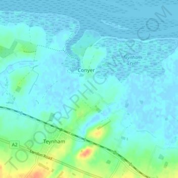
Name: Topografische Karte Teynham, Höhe, Relief.

Ort: Teynham, Borough of Swale, Kent, England, United Kingdom (51.32228 0.78900 51.36301 0.85191)

Durchschnittliche Höhe: 6 m

Minimale Höhe: -6 m

Maximale Höhe: 36 m

👉 Easily get elevation data in JSON, GeoTIFF and KML formats using Elevation API
Vielen Dank für die Unterstützung dieser Website ❤️
Spenden

Andere topografische Karten

Klicken Sie auf eine Karte, um ihre Topografie, ihre Höhe und ihr Relief anzuzeigen.

Sittingbourne

United Kingdom > England > Kent > Borough of Swale

Durchschnittliche Höhe: 37 m

The Swale

United Kingdom > England > Kent > Borough of Swale

Durchschnittliche Höhe: 12 m

Newhouse

United Kingdom > England > Kent > Borough of Swale

Durchschnittliche Höhe: 9 m

Gore

United Kingdom > England > Kent > Borough of Swale > Upchurch

Durchschnittliche Höhe: 19 m

Vielen Dank für die Unterstützung dieser Website ❤️
Spenden

Minster

United Kingdom > England > Kent > Borough of Swale

Durchschnittliche Höhe: 9 m

Bay View

United Kingdom > England > Kent > Borough of Swale > Warden

Durchschnittliche Höhe: 12 m

Keycol Hill

United Kingdom > England > Kent > Borough of Swale

Durchschnittliche Höhe: 40 m

Leysdown-on-Sea

United Kingdom > England > Kent > Borough of Swale

Durchschnittliche Höhe: 5 m

Norton Ash

United Kingdom > England > Kent > Borough of Swale > Norton

Durchschnittliche Höhe: 30 m

Lower Hartlip

United Kingdom > England > Kent > Borough of Swale > Hartlip

Durchschnittliche Höhe: 55 m

Howt Green

United Kingdom > England > Kent > Borough of Swale > Bobbing

Durchschnittliche Höhe: 19 m

Key Street

United Kingdom > England > Kent > Borough of Swale > Borden

Durchschnittliche Höhe: 40 m

Berryfield

United Kingdom > England > Kent > Borough of Swale > Eastchurch

Durchschnittliche Höhe: 22 m

Berryfield

United Kingdom > England > Kent > Borough of Swale > Eastchurch

Durchschnittliche Höhe: 22 m

Wallend

United Kingdom > England > Kent > Borough of Swale > Minster

Durchschnittliche Höhe: 7 m

Grove End

United Kingdom > England > Kent > Borough of Swale > Tunstall

Durchschnittliche Höhe: 65 m

Trouts

United Kingdom > England > Kent > Borough of Swale > Eastchurch

Durchschnittliche Höhe: 24 m

Sittingbourne

United Kingdom > England > Kent > Borough of Swale

Durchschnittliche Höhe: 37 m

Uplees

United Kingdom > England > Kent > Borough of Swale

Durchschnittliche Höhe: 5 m

Hook's Hole

United Kingdom > England > Kent > Borough of Swale > Borden

Durchschnittliche Höhe: 45 m

Vielen Dank für die Unterstützung dieser Website ❤️
Spenden

Oare Creek

United Kingdom > England > Kent > Borough of Swale > Faversham > Oare

Durchschnittliche Höhe: 6 m

Norton

United Kingdom > England > Kent > Borough of Swale

Durchschnittliche Höhe: 35 m

Seed

United Kingdom > England > Kent > Borough of Swale > Doddington

Durchschnittliche Höhe: 101 m

Graveney

United Kingdom > England > Kent > Borough of Swale

Durchschnittliche Höhe: 8 m

Halfway

United Kingdom > England > Kent > Borough of Swale

Durchschnittliche Höhe: 6 m

Faversham Creek

United Kingdom > England > Kent > Borough of Swale > Faversham > Oare

Durchschnittliche Höhe: 11 m

Great Norwood

United Kingdom > England > Kent > Borough of Swale > Bobbing

Durchschnittliche Höhe: 27 m

Faversham Creek

United Kingdom > England > Kent > Borough of Swale > Faversham > Oare

Durchschnittliche Höhe: 8 m

Lewson Street

United Kingdom > England > Kent > Borough of Swale > Norton

Durchschnittliche Höhe: 36 m

Dargate

United Kingdom > England > Kent > Borough of Swale

Durchschnittliche Höhe: 40 m

Whitehill

United Kingdom > England > Kent > Borough of Swale > Painter's Forstal

Durchschnittliche Höhe: 45 m

Oversland

United Kingdom > England > Kent > Borough of Swale

Durchschnittliche Höhe: 73 m

Ham Green

United Kingdom > England > Kent > Borough of Swale > Upchurch

Durchschnittliche Höhe: 4 m

Rüsten Sie sich für Ihr nächstes Abenteuer:

🧼Seifenkonzentrate - Kompakte Hygiene für Körper, Haare und Kleidung
🧣Multifunktionstücher - Vielseitiger Schutz für Hals, Kopf und Gesicht
📱Outdoor-Handyhalterungen - Sichere Befestigung für die Navigation am Lenker
🛏️Selbstaufblasbare Isomatte - Komfortable Schlafunterlage für Outdoor
🦟Insektenschutzmittel - Effektive Abwehr von Zecken und Mücken im Wald

Als Amazon-Partner erhält diese Website eine Provision für qualifizierte Käufe, ohne zusätzliche Kosten für Sie.