
Topografische Karte Dandenong Ranges
Interaktive Karte
Klicken Sie auf die Karte, um die Höhe anzuzeigen.
Über diese Karte
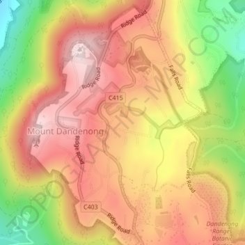
Name: Topografische Karte Dandenong Ranges, Höhe, Relief.
Durchschnittliche Höhe: 456 m
Minimale Höhe: 213 m
Maximale Höhe: 621 m
The topography consists of a series of ridges dissected by deeply cut streams. Sheltered gullies in the south of the range are home to temperate rain forest, fern gullies and Mountain Ash forest Eucalyptus regnans, whereas the drier ridges and exposed northern slopes are covered by dry sclerophyll forest of stringybarks and box. The entire range is highly prone to bushfires, the most recent of which have been the 1983 Ash Wednesday bushfires, the 1997 Dandenong Ranges bushfires and small fires during the Black Saturday bushfires in 2009.
Andere topografische Karten
Klicken Sie auf eine Karte, um ihre Topografie, ihre Höhe und ihr Relief anzuzeigen.
Surrey Hills
Australia > Victoria > Melbourne
Surrey Hills, Melbourne, City of Boroondara, Victoria, 3127, Australia
Durchschnittliche Höhe: 96 m
Williamstown
Australia > Victoria > Melbourne
Williamstown, Melbourne, City of Hobsons Bay, Victoria, 3016, Australia
Durchschnittliche Höhe: 4 m
Chirnside Park
Australia > Victoria > Melbourne
Chirnside Park, Melbourne, Shire of Yarra Ranges, Victoria, 3116, Australia
Durchschnittliche Höhe: 102 m
Canterbury
Australia > Victoria > Melbourne
Canterbury, Melbourne, City of Boroondara, Victoria, 3126, Australia
Durchschnittliche Höhe: 78 m
Maribyrnong River
Australia > Victoria > Melbourne
Maribyrnong River, Melbourne, City of Moonee Valley, Victoria, 3036, Australia
Durchschnittliche Höhe: 60 m
Melbourne District
Australia > Victoria > Melbourne
Melbourne District, Melbourne, City of Melbourne, Victoria, Australia
Durchschnittliche Höhe: 20 m
Wattle Glen
Australia > Victoria > Melbourne > Wattle Glen
Wattle Glen, Melbourne, Shire of Nillumbik, Victoria, 3096, Australia
Durchschnittliche Höhe: 121 m
Tarneit District
Australia > Victoria > Melbourne
Tarneit District, Melbourne, City of Wyndham, Victoria, Australia
Durchschnittliche Höhe: 45 m
Melbourne Water Retarding Basin RB18
Australia > Victoria > Melbourne
Melbourne Water Retarding Basin RB18, Mount Waverley, Melbourne, City of Monash, Victoria, Australia
Durchschnittliche Höhe: 109 m
Cranbourne East
Australia > Victoria > Melbourne
Cranbourne East, Melbourne, City of Casey, Victoria, Australia
Durchschnittliche Höhe: 45 m
Iramoo Wildlife Park
Australia > Victoria > Melbourne > Cairnlea
Iramoo Wildlife Park, Litoria Lane, St Albans, Cairnlea, Melbourne, City of Brimbank, Victoria, 3023, Australia
Durchschnittliche Höhe: 63 m
Science Garden
Australia > Victoria > Melbourne > Meadow Heights
Science Garden, Greenvale, Meadow Heights, Melbourne, City of Hume, Victoria, Australia
Durchschnittliche Höhe: 174 m
Albert Park District
Australia > Victoria > Melbourne
Albert Park District, Melbourne, City of Port Phillip, Victoria, Australia
Durchschnittliche Höhe: 10 m