
Topografische Karte Hinchinbrooke
Interaktive Karte
Klicken Sie auf die Karte, um die Höhe anzuzeigen.
Über diese Karte
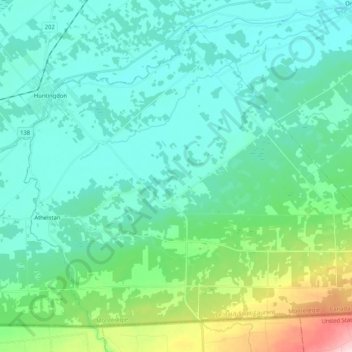
Name: Topografische Karte Hinchinbrooke, Höhe, Relief.
Durchschnittliche Höhe: 78 m
Minimale Höhe: 33 m
Maximale Höhe: 272 m
Andere topografische Karten
Klicken Sie auf eine Karte, um ihre Topografie, ihre Höhe und ihr Relief anzuzeigen.
Havelock
Canada > Quebec > Le Haut-Saint-Laurent
Havelock, Le Haut-Saint-Laurent, Montérégie, Quebec, J0S 2C0, Canada
Durchschnittliche Höhe: 122 m
North Georgetown
Canada > Quebec > Le Haut-Saint-Laurent
North Georgetown, Très-Saint-Sacrement, Le Haut-Saint-Laurent, Montérégie, Quebec, J0S 1G0, Canada
Durchschnittliche Höhe: 40 m
Cazaville
Canada > Quebec > Le Haut-Saint-Laurent
Cazaville, Saint-Anicet, Le Haut-Saint-Laurent, Montérégie, Quebec, J0S 1B0, Canada
Durchschnittliche Höhe: 58 m
Sainte-Agnès-de-Dundee
Canada > Quebec > Le Haut-Saint-Laurent
Sainte-Agnès-de-Dundee, Le Haut-Saint-Laurent, Montérégie, Quebec, J0S 1L0, Canada
Durchschnittliche Höhe: 60 m
Snye
Canada > Quebec > Le Haut-Saint-Laurent > Snye
Snye, Le Haut-Saint-Laurent, Montérégie, Quebec, Canada
Durchschnittliche Höhe: 49 m
Saint-Anicet
Canada > Quebec > Le Haut-Saint-Laurent
Saint-Anicet, Le Haut-Saint-Laurent, Montérégie, Quebec, Canada
Durchschnittliche Höhe: 53 m
Ormstown
Canada > Quebec > Le Haut-Saint-Laurent
Ormstown, Le Haut-Saint-Laurent, Montérégie, Quebec, J0S 1K0, Canada
Durchschnittliche Höhe: 63 m
Franklin
Canada > Quebec > Le Haut-Saint-Laurent
Franklin, Le Haut-Saint-Laurent, Montérégie, Quebec, Canada
Durchschnittliche Höhe: 147 m
Covey Hill
Canada > Quebec > Le Haut-Saint-Laurent > Havelock
Covey Hill, Havelock, Le Haut-Saint-Laurent, Montérégie, Quebec, J0S 2C0, Canada
Durchschnittliche Höhe: 283 m