
Topografische Karte Hansford
Interaktive Karte
Klicken Sie auf die Karte, um die Höhe anzuzeigen.
Über diese Karte
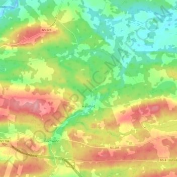
Name: Topografische Karte Hansford, Höhe, Relief.
Durchschnittliche Höhe: 54 m
Minimale Höhe: -4 m
Maximale Höhe: 118 m
Andere topografische Karten
Klicken Sie auf eine Karte, um ihre Topografie, ihre Höhe und ihr Relief anzuzeigen.
Hastings
Canada > Nova Scotia > Municipality of the County of Cumberland
Hastings, Municipality of the County of Cumberland, Cumberland County, Nova Scotia, B4H 3Y3, Canada
Durchschnittliche Höhe: 63 m
Brookdale
Canada > Nova Scotia > Municipality of the County of Cumberland
Brookdale, Municipality of the County of Cumberland, Cumberland County, Nova Scotia, B4H 3Y3, Canada
Durchschnittliche Höhe: 52 m
Southampton
Canada > Nova Scotia > Municipality of the County of Cumberland
Southampton, Municipality of the County of Cumberland, Cumberland County, Nova Scotia, B0M 1W0, Canada
Durchschnittliche Höhe: 78 m
Port Philip
Canada > Nova Scotia > Municipality of the County of Cumberland
Port Philip, Municipality of the County of Cumberland, Cumberland County, Nova Scotia, B0K 1L0, Canada
Durchschnittliche Höhe: 12 m
Muddy Plains
Canada > Nova Scotia > Municipality of the County of Cumberland > Shulie
Muddy Plains, Shulie, Municipality of the County of Cumberland, Cumberland County, Nova Scotia, B0L 1A0, Canada
Durchschnittliche Höhe: 125 m