
Spenden
Rüsten Sie sich für Ihr nächstes Abenteuer:
Als Amazon-Partner erhält diese Website eine Provision für qualifizierte Käufe, ohne zusätzliche Kosten für Sie.
Topografische Karte Nederland
Klicken Sie auf die Karte, um die Höhe anzuzeigen.
Spenden
Rüsten Sie sich für Ihr nächstes Abenteuer:
Als Amazon-Partner erhält diese Website eine Provision für qualifizierte Käufe, ohne zusätzliche Kosten für Sie.
Nederland
In 1873 the Caribou Mine, at an elevation of roughly 10,000 feet (3,000 m) and 6 miles (10 km) northwest of the town, was sold to the Mining Company Nederland from the Netherlands. The high elevation meant fierce winds and deep winter snow, so the new owners of the mine decided that it was beneficial to bring ore from Caribou down to Middle Boulder for milling. In the Dutch language, Nederland ("Netherlands" in English) means low land, and based on casual usage by the Dutch miners, Middle Boulder came to be known as Nederland. In 1874 the town was incorporated and adopted Nederland as the official name.
Spenden
Rüsten Sie sich für Ihr nächstes Abenteuer:
Als Amazon-Partner erhält diese Website eine Provision für qualifizierte Käufe, ohne zusätzliche Kosten für Sie.
Über diese Karte
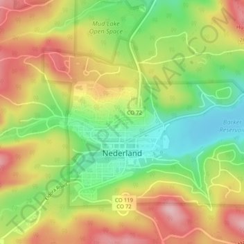
Name: Topografische Karte Nederland, Höhe, Relief.
Ort: Nederland, Boulder County, Colorado, 80466, United States (39.95498 -105.52334 39.97532 -105.48418)
Durchschnittliche Höhe: 2.578 m
Minimale Höhe: 2.482 m
Maximale Höhe: 2.677 m
Spenden
Rüsten Sie sich für Ihr nächstes Abenteuer:
Als Amazon-Partner erhält diese Website eine Provision für qualifizierte Käufe, ohne zusätzliche Kosten für Sie.
Andere topografische Karten
Klicken Sie auf eine Karte, um ihre Topografie, ihre Höhe und ihr Relief anzuzeigen.
Boulder
United States > Colorado > Boulder County
Boulder is located at the base of the foothills of the Rocky Mountains, at an elevation of 5,430 feet (1,655 m) above sea level. Boulder is 25 miles (40 km) northwest of the Colorado state capital of Denver. It is home of the main campus of the University of Colorado, the state's largest university.
Durchschnittliche Höhe: 1.800 m
Longmont
United States > Colorado > Boulder County
The elevation at City Hall is 4,978 feet (1,517 m) above sea level. St. Vrain Creek, a tributary of the South Platte River, flows through the city just south of the city center.
Durchschnittliche Höhe: 1.537 m
Spenden
Rüsten Sie sich für Ihr nächstes Abenteuer:
Als Amazon-Partner erhält diese Website eine Provision für qualifizierte Käufe, ohne zusätzliche Kosten für Sie.
Ward
United States > Colorado > Boulder County
Ward is a home rule municipality in Boulder County, Colorado, United States. The population was 128 at the 2020 census. The town is a former mining settlement founded in 1860 in the wake of the discovery of gold at nearby Gold Hill. Once one of the richest towns in the state during the Colorado Gold Rush, it…
Durchschnittliche Höhe: 2.826 m
Spenden
Rüsten Sie sich für Ihr nächstes Abenteuer:
Als Amazon-Partner erhält diese Website eine Provision für qualifizierte Käufe, ohne zusätzliche Kosten für Sie.
Longs Peak
United States > Colorado > Boulder County
Together with nearby Mount Meeker, with an elevation of 13,911 feet, the two mountains are sometimes referred to as the Twin Peaks (not to be confused with a nearby lower mountain called Twin Sisters).
Durchschnittliche Höhe: 3.825 m
Spenden
Rüsten Sie sich für Ihr nächstes Abenteuer:
Als Amazon-Partner erhält diese Website eine Provision für qualifizierte Käufe, ohne zusätzliche Kosten für Sie.
Nederland
United States > Colorado > Boulder County
In 1873 the Caribou Mine, at an elevation of roughly 10,000 feet (3,000 m) and 6 miles (10 km) northwest of the town, was sold to the Mining Company Nederland from the Netherlands. The high elevation meant fierce winds and deep winter snow, so the new owners of the mine decided that it was beneficial to bring…
Durchschnittliche Höhe: 2.578 m
Spenden
Rüsten Sie sich für Ihr nächstes Abenteuer:
Als Amazon-Partner erhält diese Website eine Provision für qualifizierte Käufe, ohne zusätzliche Kosten für Sie.
Boulder
United States > Colorado > Boulder County
Boulder is located at the base of the foothills of the Rocky Mountains, at an elevation of 5,430 feet (1,655 m) above sea level. The city is 25 miles (40 km) northwest of the Colorado state capital of Denver. Boulder is a college town, hosting the University of Colorado Boulder, the flagship and largest campus…
Durchschnittliche Höhe: 1.800 m
Longs Peak
United States > Colorado > Boulder County
Together with nearby Mount Meeker, with an elevation of 13,911 feet, the two mountains are sometimes referred to as the Twin Peaks (not to be confused with a nearby lower mountain called Twin Sisters).
Durchschnittliche Höhe: 3.825 m
Longmont
United States > Colorado > Boulder County
The elevation at City Hall is 4,978 feet (1,517 m) above sea level. St. Vrain Creek, a tributary of the South Platte River, flows through the city just south of the city center.
Durchschnittliche Höhe: 1.537 m
Spenden
Rüsten Sie sich für Ihr nächstes Abenteuer:
Als Amazon-Partner erhält diese Website eine Provision für qualifizierte Käufe, ohne zusätzliche Kosten für Sie.
Monument Hill
United States > Colorado > Boulder County
Monument Hill or Black Forest Divide Pass is a 7,352 feet (2,241 m) elevation mountain pass in the Palmer Divide in central Colorado in the United States. The pass dividing the Arkansas River drainage system to the south and the Platte River drainage system to the north is the high point on I-25 between Denver…
Durchschnittliche Höhe: 2.315 m
Boulder
United States > Colorado > Boulder County
Boulder is located at the base of the foothills of the Rocky Mountains, at an elevation of 5,430 feet (1,655 m) above sea level. The city is 25 miles (40 km) northwest of the Colorado state capital of Denver. Boulder is a college town, hosting the University of Colorado Boulder, the flagship and largest campus…
Durchschnittliche Höhe: 1.800 m
Spenden
Rüsten Sie sich für Ihr nächstes Abenteuer:
Als Amazon-Partner erhält diese Website eine Provision für qualifizierte Käufe, ohne zusätzliche Kosten für Sie.
Allenspark
United States > Colorado > Boulder County > Allenspark
Allenspark is located in northwest Boulder County within Roosevelt National Forest in the Front Range of the Colorado Rockies. The western edge of the community is the boundary of Rocky Mountain National Park. State Highway 7 passes through the community, leading north 15 miles (24 km) to Estes Park and east…
Durchschnittliche Höhe: 2.874 m
Spenden
Rüsten Sie sich für Ihr nächstes Abenteuer:
Als Amazon-Partner erhält diese Website eine Provision für qualifizierte Käufe, ohne zusätzliche Kosten für Sie.
Boulder
United States > Colorado > Boulder County
Boulder is located at the base of the foothills of the Rocky Mountains, at an elevation of 5,430 feet (1,655 m) above sea level. The city is 25 miles (40 km) northwest of the Colorado state capital of Denver. Boulder is a college town, hosting the University of Colorado Boulder, the flagship and largest campus…
Durchschnittliche Höhe: 1.800 m
Ward
United States > Colorado > Boulder County
Ward is a home rule municipality in Boulder County, Colorado, United States. The population was 128 at the 2020 census. The town is a former mining settlement founded in 1860 in the wake of the discovery of gold at nearby Gold Hill. Once one of the richest towns in the state during the Colorado Gold Rush, it…
Durchschnittliche Höhe: 2.826 m
Boulder
United States > Colorado > Boulder County
Boulder is located at the base of the foothills of the Rocky Mountains, at an elevation of 5,430 feet (1,655 m) above sea level. The city is 25 miles (40 km) northwest of the Colorado state capital of Denver. Boulder is a college town, hosting the University of Colorado Boulder, the flagship and largest campus…
Durchschnittliche Höhe: 1.800 m
Allenspark
United States > Colorado > Boulder County
Allenspark is located in northwest Boulder County within Roosevelt National Forest in the Front Range of the Colorado Rockies. The western edge of the community is the boundary of Rocky Mountain National Park. State Highway 7 passes through the community, leading north 15 miles (24 km) to Estes Park and east…
Durchschnittliche Höhe: 2.874 m
Spenden
Rüsten Sie sich für Ihr nächstes Abenteuer:
Als Amazon-Partner erhält diese Website eine Provision für qualifizierte Käufe, ohne zusätzliche Kosten für Sie.
Nederland
United States > Colorado > Boulder County
In 1873 the Caribou Mine, at an elevation of roughly 10,000 feet (3,000 m) and 6 miles (10 km) northwest of the town, was sold to the Mining Company Nederland from the Netherlands. The high elevation meant fierce winds and deep winter snow, so the new owners of the mine decided that it was beneficial to bring…
Durchschnittliche Höhe: 2.578 m
Boulder
United States > Colorado > Boulder County
Boulder is located at the base of the foothills of the Rocky Mountains, at an elevation of 5,430 feet (1,655 m) above sea level. The city is 25 miles (40 km) northwest of the Colorado state capital of Denver. Boulder is a college town, hosting the largest campus of the University of Colorado (the state's…
Durchschnittliche Höhe: 1.800 m
Longmont
United States > Colorado > Boulder County
The elevation at City Hall is 4,978 feet (1,517 m) above sea level. St. Vrain Creek, a tributary of the South Platte River, flows through the city just south of the city center.
Durchschnittliche Höhe: 1.534 m
Spenden
Rüsten Sie sich für Ihr nächstes Abenteuer:
Als Amazon-Partner erhält diese Website eine Provision für qualifizierte Käufe, ohne zusätzliche Kosten für Sie.
Spenden
Rüsten Sie sich für Ihr nächstes Abenteuer:
Als Amazon-Partner erhält diese Website eine Provision für qualifizierte Käufe, ohne zusätzliche Kosten für Sie.
Boulder
United States > Colorado > Boulder County > Boulder
Boulder is located at the base of the foothills of the Rocky Mountains, at an elevation of 5,430 feet (1,655 m) above sea level. Boulder is 25 miles (40 km) northwest of the Colorado State Capitol in Denver. It is home of the main campus of the University of Colorado, the state's largest university.
Durchschnittliche Höhe: 1.977 m
Spenden
Rüsten Sie sich für Ihr nächstes Abenteuer:
Als Amazon-Partner erhält diese Website eine Provision für qualifizierte Käufe, ohne zusätzliche Kosten für Sie.
Sunshine Canyon Drive
United States > Colorado > Boulder County > Gold Hill
Durchschnittliche Höhe: 2.438 m
Spenden
Rüsten Sie sich für Ihr nächstes Abenteuer:
Als Amazon-Partner erhält diese Website eine Provision für qualifizierte Käufe, ohne zusätzliche Kosten für Sie.