
Spenden
Rüsten Sie sich für Ihr nächstes Abenteuer:
Als Amazon-Partner erhält diese Website eine Provision für qualifizierte Käufe, ohne zusätzliche Kosten für Sie.
Topografische Karte Kirkland Lake
Klicken Sie auf die Karte, um die Höhe anzuzeigen.
Spenden
Rüsten Sie sich für Ihr nächstes Abenteuer:
Als Amazon-Partner erhält diese Website eine Provision für qualifizierte Käufe, ohne zusätzliche Kosten für Sie.
Kirkland Lake
Kirkland Lake is located in the resource-rich Precambrian Shield, an ancient geological core of the North American continent. Nearby is the Arctic Watershed, a drainage divide at an elevation of 318 m (1,043 ft). Rivers south of that elevation flow into a drainage basin which includes Lake Ontario and the Saint Lawrence River, while rivers north of the watershed flow into Hudson Bay.
Spenden
Rüsten Sie sich für Ihr nächstes Abenteuer:
Als Amazon-Partner erhält diese Website eine Provision für qualifizierte Käufe, ohne zusätzliche Kosten für Sie.
Über diese Karte
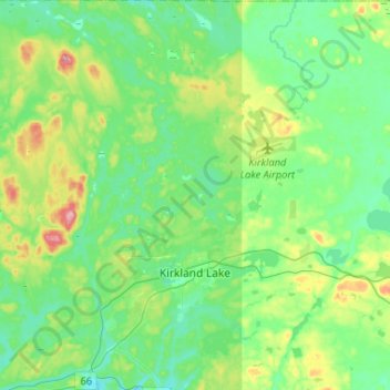
Name: Topografische Karte Kirkland Lake, Höhe, Relief.
Durchschnittliche Höhe: 332 m
Minimale Höhe: 294 m
Maximale Höhe: 443 m
Spenden
Rüsten Sie sich für Ihr nächstes Abenteuer:
Als Amazon-Partner erhält diese Website eine Provision für qualifizierte Käufe, ohne zusätzliche Kosten für Sie.
Andere topografische Karten
Klicken Sie auf eine Karte, um ihre Topografie, ihre Höhe und ihr Relief anzuzeigen.
New Liskeard
Canada > Ontario > Timiskaming District > Temiskaming Shores
Durchschnittliche Höhe: 212 m
Larder Lake
Canada > Ontario > Timiskaming District > Larder Lake Township
Durchschnittliche Höhe: 300 m
Henwood Lake
Canada > Ontario > Timiskaming District > Unorganized West Timiskaming
Durchschnittliche Höhe: 288 m
Spenden
Rüsten Sie sich für Ihr nächstes Abenteuer:
Als Amazon-Partner erhält diese Website eine Provision für qualifizierte Käufe, ohne zusätzliche Kosten für Sie.
Spenden
Rüsten Sie sich für Ihr nächstes Abenteuer:
Als Amazon-Partner erhält diese Website eine Provision für qualifizierte Käufe, ohne zusätzliche Kosten für Sie.
Boston Creek
Canada > Ontario > Timiskaming District > Unorganized West Timiskaming
Durchschnittliche Höhe: 300 m
Heart Lake
Canada > Ontario > Timiskaming District > Unorganized West Timiskaming > King Kirkland
Durchschnittliche Höhe: 336 m
Spenden
Rüsten Sie sich für Ihr nächstes Abenteuer:
Als Amazon-Partner erhält diese Website eine Provision für qualifizierte Käufe, ohne zusätzliche Kosten für Sie.
Kenabeek
Canada > Ontario > Timiskaming District > Unorganized West Timiskaming
Durchschnittliche Höhe: 284 m
Hobart Lake
Canada > Ontario > Timiskaming District > Unorganized West Timiskaming
Durchschnittliche Höhe: 305 m
Flanagan Lake
Canada > Ontario > Timiskaming District > Unorganized West Timiskaming
Durchschnittliche Höhe: 403 m
Hell's Gate
Canada > Ontario > Timiskaming District > Evanturel Township
Durchschnittliche Höhe: 237 m
Spenden
Rüsten Sie sich für Ihr nächstes Abenteuer:
Als Amazon-Partner erhält diese Website eine Provision für qualifizierte Käufe, ohne zusätzliche Kosten für Sie.
Baptiste Creek;Baptiste Lake
Canada > Ontario > Timiskaming District > Unorganized West Timiskaming
Durchschnittliche Höhe: 334 m
Spenden
Rüsten Sie sich für Ihr nächstes Abenteuer:
Als Amazon-Partner erhält diese Website eine Provision für qualifizierte Käufe, ohne zusätzliche Kosten für Sie.
New Liskeard
Canada > Ontario > Timiskaming District > Temiskaming Shores
Durchschnittliche Höhe: 212 m