
Topografische Karte Ol Doinyo Lengai
Interaktive Karte
Klicken Sie auf die Karte, um die Höhe anzuzeigen.
Über diese Karte
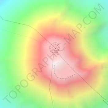
Name: Topografische Karte Ol Doinyo Lengai, Höhe, Relief.
Ort: Ol Doinyo Lengai, Ngorongoro, Arusha, Northern Zone, Tanzanie (-2.76097 35.91371 -2.76087 35.91381)
Durchschnittliche Höhe: 2.369 m
Minimale Höhe: 1.730 m
Maximale Höhe: 2.940 m
Andere topografische Karten
Klicken Sie auf eine Karte, um ihre Topografie, ihre Höhe und ihr Relief anzuzeigen.
Makao Mapya
Tanzanie > Arusha > Makao Mapya
Makao Mapya, Arumeru, Arusha, Northern Zone, Tanzanie
Durchschnittliche Höhe: 911 m
Mount Meru
Mount Meru, Arumeru, Arusha, Northern Zone, Tanzanie
Durchschnittliche Höhe: 3.884 m
Ndutu Ranger Post
Ndutu Ranger Post, Ngorongoro, Arusha, Northern Zone, Tanzanie
Durchschnittliche Höhe: 1.616 m
Lac Natron
Lac Natron, Ngorongoro, Arusha, Northern Zone, Tanzanie
Durchschnittliche Höhe: 861 m