
Topografische Karte Area F (Columbia Lake/Windermere Lake)
Interaktive Karte
Klicken Sie auf die Karte, um die Höhe anzuzeigen.
Über diese Karte
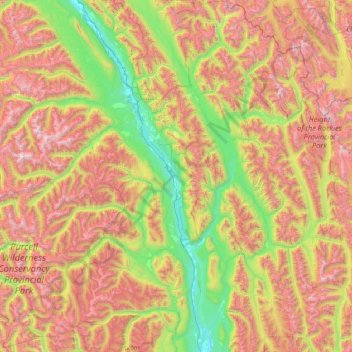
Name: Topografische Karte Area F (Columbia Lake/Windermere Lake), Höhe, Relief.
Durchschnittliche Höhe: 1.815 m
Minimale Höhe: 775 m
Maximale Höhe: 3.425 m
Andere topografische Karten
Klicken Sie auf eine Karte, um ihre Topografie, ihre Höhe und ihr Relief anzuzeigen.
Fairmont Hot Springs
Canada > British Columbia > Regional District of East Kootenay > Area F (Columbia Lake/Windermere Lake)
Fairmont Hot Springs, Area F (Columbia Lake/Windermere Lake), Regional District of East Kootenay, British Columbia, V0B 1L0, Canada
Durchschnittliche Höhe: 920 m
Whiteswan Lake
Canada > British Columbia > Regional District of East Kootenay > Area F (Columbia Lake/Windermere Lake)
Whiteswan Lake, Area F (Columbia Lake/Windermere Lake), Regional District of East Kootenay, British Columbia, Canada
Durchschnittliche Höhe: 1.392 m
Shuswap
Canada > British Columbia > Regional District of East Kootenay > Area F (Columbia Lake/Windermere Lake)
Shuswap, Area F (Columbia Lake/Windermere Lake), Regional District of East Kootenay, British Columbia, V0A 1K3, Canada
Durchschnittliche Höhe: 926 m