
Topografische Karte Riding Mountain National Park
Interaktive Karte
Klicken Sie auf die Karte, um die Höhe anzuzeigen.
Über diese Karte
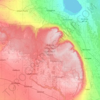
Name: Topografische Karte Riding Mountain National Park, Höhe, Relief.
Durchschnittliche Höhe: 488 m
Minimale Höhe: 258 m
Maximale Höhe: 749 m
Riding Mountain Biosphere Reserve covers 15,000 square kilometers of land in South-western Manitoba, with the core area, Riding Mountain National Park (RMNP), covering nearly 3,000 square kilometers. It is some 300 km northwest of Winnipeg, Manitoba. The local climate is cool and moist due to a higher elevation than the surrounding area. Due to these unique conditions, several different ecosystems are present in the vicinity of the park, including the deciduous forest, boreal forest, and grassland.