
Topografische Karte Palm Beach County
Interaktive Karte
Klicken Sie auf die Karte, um die Höhe anzuzeigen.
Über diese Karte
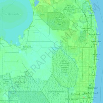
Name: Topografische Karte Palm Beach County, Höhe, Relief.
Ort: Palm Beach County, Florida, United States of America (26.32068 -80.88623 26.97092 -79.97431)
Durchschnittliche Höhe: 5 m
Minimale Höhe: -3 m
Maximale Höhe: 42 m
Andere topografische Karten
Klicken Sie auf eine Karte, um ihre Topografie, ihre Höhe und ihr Relief anzuzeigen.
Key West
United States of America > Florida > Key West
Key West, Monroe County, Florida, United States of America
Durchschnittliche Höhe: 1 m
Collier County
United States of America > Florida
Collier County, Florida, United States of America
Durchschnittliche Höhe: 5 m
Sarasota County
United States of America > Florida
Sarasota County, Florida, United States of America
Durchschnittliche Höhe: 7 m
Sumter County
United States of America > Florida
Sumter County, Florida, United States of America
Durchschnittliche Höhe: 27 m
Hendry County
United States of America > Florida
Hendry County, Florida, United States of America
Durchschnittliche Höhe: 8 m
Baker County
United States of America > Florida
Baker County, Florida, United States of America
Durchschnittliche Höhe: 40 m
Altamonte Springs
United States of America > Florida > Altamonte Springs
Altamonte Springs, Seminole County, Florida, United States of America
Durchschnittliche Höhe: 26 m
Pembroke Pines
United States of America > Florida > Pembroke Pines
Pembroke Pines, Broward County, Florida, United States of America
Durchschnittliche Höhe: 5 m