
Topografische Karte Ax-les-Thermes
Interaktive Karte
Klicken Sie auf die Karte, um die Höhe anzuzeigen.
Über diese Karte
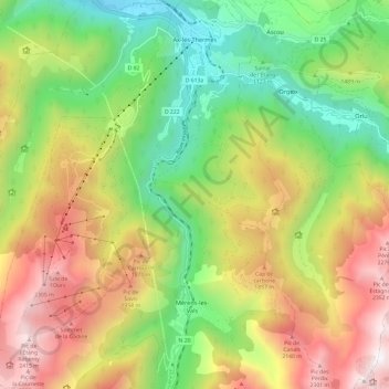
Name: Topografische Karte Ax-les-Thermes, Höhe, Relief.
Durchschnittliche Höhe: 1.449 m
Minimale Höhe: 665 m
Maximale Höhe: 2.473 m
Ax (from Latin Aquae – water; French Thermes – hot springs), situated at an elevation of 700 metres (2,300 ft), is well known for its sulphurous hot springs (25 to 78 °C or 77 to 172 °F). The waters, which were used by the Romans, were historically claimed to treat rheumatism, skin diseases, and other maladies. The springs were developed in the medieval period on the orders of Saint Louis to treat soldiers returning from the Crusades afflicted with leprosy. From the 19th century, a spa tourism industry developed.
Andere topografische Karten
Klicken Sie auf eine Karte, um ihre Topografie, ihre Höhe und ihr Relief anzuzeigen.
L'Hospitalet-près-l'Andorre
L'Hospitalet-près-l'Andorre, Foix, Ariège, Occitania, Metropolitan France, 09390, France
Durchschnittliche Höhe: 2.024 m
Aigues-Vives
Aigues-Vives, Pamiers, Ariège, Occitania, Metropolitan France, 09600, France
Durchschnittliche Höhe: 453 m
Pointe ronde
France > Occitania > Ariège > Ustou
Pointe ronde, Ustou, Saint-Girons, Ariège, Occitania, Metropolitan France, 09140, France
Durchschnittliche Höhe: 1.814 m
Arrien-en-Bethmale
France > Occitania > Ariège > Arrien-en-Bethmale
Arrien-en-Bethmale, Saint-Girons, Ariège, Occitania, Metropolitan France, 09800, France
Durchschnittliche Höhe: 1.098 m
Les Cabannes
France > Occitania > Ariège > Les Cabannes
Les Cabannes, Foix, Ariège, Occitania, Metropolitan France, 09310, France
Durchschnittliche Höhe: 653 m
Fougax-et-Barrineuf
France > Occitania > Ariège > Fougax-et-Barrineuf
Fougax-et-Barrineuf, Pamiers, Ariège, Occitania, Metropolitan France, 09300, France
Durchschnittliche Höhe: 877 m
Mercus-Garrabet
Mercus-Garrabet, Foix, Ariège, Occitania, Metropolitan France, 09400, France
Durchschnittliche Höhe: 726 m
La Bastide-de-Sérou
La Bastide-de-Sérou, Saint-Girons, Ariège, Occitania, Metropolitan France, 09240, France
Durchschnittliche Höhe: 500 m
Saint-Girons
Saint-Girons, Ariège, Occitania, Metropolitan France, 09200, France
Durchschnittliche Höhe: 566 m