
Topografische Karte Totton and Eling
Interaktive Karte
Klicken Sie auf die Karte, um die Höhe anzuzeigen.
Über diese Karte
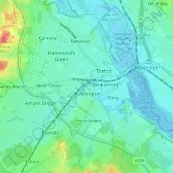
Name: Topografische Karte Totton and Eling, Höhe, Relief.
Durchschnittliche Höhe: 13 m
Minimale Höhe: -4 m
Maximale Höhe: 60 m
Andere topografische Karten
Klicken Sie auf eine Karte, um ihre Topografie, ihre Höhe und ihr Relief anzuzeigen.
Martin
United Kingdom > England > New Forest
Martin, New Forest, Hampshire, South East, England, United Kingdom
Durchschnittliche Höhe: 103 m
Fordingbridge
United Kingdom > England > New Forest
Fordingbridge, New Forest, Hampshire, South East, England, United Kingdom
Durchschnittliche Höhe: 46 m
Lymington and Pennington
United Kingdom > England > New Forest
Lymington and Pennington, New Forest, Hampshire, South East, England, United Kingdom
Durchschnittliche Höhe: 9 m
Copythorne
United Kingdom > England > New Forest
Copythorne, New Forest, Hampshire, South East, England, United Kingdom
Durchschnittliche Höhe: 36 m