
Topografische Karte Irish Lake
Interaktive Karte
Klicken Sie auf die Karte, um die Höhe anzuzeigen.
Über diese Karte
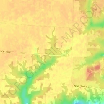
Name: Topografische Karte Irish Lake, Höhe, Relief.
Durchschnittliche Höhe: 214 m
Minimale Höhe: 181 m
Maximale Höhe: 225 m
Andere topografische Karten
Klicken Sie auf eine Karte, um ihre Topografie, ihre Höhe und ihr Relief anzuzeigen.
Charleston Lake
USA > Illinois > Charleston
Charleston Lake, Charleston, Coles County, Illinois, USA
Durchschnittliche Höhe: 193 m
Baldwin Heights
USA > Illinois > Baldwin Heights
Baldwin Heights, Jefferson County, Illinois, 62848, USA
Durchschnittliche Höhe: 165 m
Hainesville
USA > Illinois > Hainesville
Hainesville, Lake County, Illinois, USA
Durchschnittliche Höhe: 242 m
Montague Island
Montague Island, Rockford, Winnebago County, Illinois, 61104, USA
Durchschnittliche Höhe: 254 m
Garfield Ridge
Garfield Ridge, Chicago, Cook County, Illinois, USA
Durchschnittliche Höhe: 184 m
Arrowsmith
USA > Illinois > Arrowsmith
Arrowsmith, McLean County, Illinois, USA
Durchschnittliche Höhe: 266 m
Illinois Medical District
USA > Illinois > Illinois Medical District
Illinois Medical District, Cook County, Illinois, USA
Durchschnittliche Höhe: 182 m
Tower Lake
USA > Illinois > Tower Lake
Tower Lake, Lake County, Illinois, USA
Durchschnittliche Höhe: 237 m
Cooksville
USA > Illinois > Cooksville
Cooksville, McLean County, Illinois, USA
Durchschnittliche Höhe: 235 m
Mount Carmel
USA > Illinois > Mount Carmel
Mount Carmel, Wabash County, Illinois, USA
Durchschnittliche Höhe: 128 m
Heidecke Lake
USA > Illinois > Harrisonville
Heidecke Lake, North Jugtown Road, Harrisonville, Grundy County, Illinois, 60450, USA
Durchschnittliche Höhe: 156 m