Geolokalisieren

Topografische Karte South Delhi

Klicken Sie auf die Karte, um die Höhe anzuzeigen.

👉 Easily get elevation data in JSON, GeoTIFF and KML formats using Elevation API
Vielen Dank für die Unterstützung dieser Website ❤️
Spenden

Rüsten Sie sich für Ihr nächstes Abenteuer:

Als Amazon-Partner erhält diese Website eine Provision für qualifizierte Käufe, ohne zusätzliche Kosten für Sie.

Über diese Karte

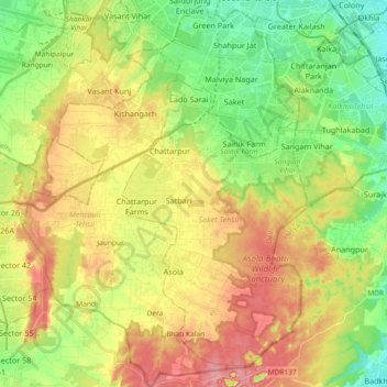
Name: Topografische Karte South Delhi, Höhe, Relief.

Ort: South Delhi, Delhi, India (28.40463 77.11247 28.56595 77.24836)

Durchschnittliche Höhe: 254 m

Minimale Höhe: 201 m

Maximale Höhe: 315 m

Andere topografische Karten

Klicken Sie auf eine Karte, um ihre Topografie, ihre Höhe und ihr Relief anzuzeigen.

DDA Park

India > Delhi

Durchschnittliche Höhe: 217 m

Safdarjung Development Area

India > Delhi

Durchschnittliche Höhe: 227 m

Tyagraj Nagar

India > Delhi

Durchschnittliche Höhe: 215 m

Yamuna River

India > Delhi

The source of Yamuna lies in the Yamunotri Glacier at an elevation of 6,387 metres (20,955 ft), on the southwestern slopes of Banderpooch peaks, which lie in the Mussoorie range of the Lower Himalayas, north of Haridwar in Uttarkashi district, Uttarakhand. Yamunotri temple, a shrine dedicated to the goddess…

Durchschnittliche Höhe: 206 m

Vielen Dank für die Unterstützung dieser Website ❤️
Spenden

Delhi

India > Delhi > Kotwali Tehsil

The topography of the medieval fort Purana Qila on the banks of the river Yamuna matches the literary description of the citadel Indraprastha in the Sanskrit epic Mahabharata; however, excavations in the area have revealed no signs of an ancient built environment. From the early 13th century until the mid-19th…

Durchschnittliche Höhe: 216 m

Aastha Kunj Park

India > Delhi > Kalkaji Tehsil

Durchschnittliche Höhe: 223 m

Mahipalpur

India > Delhi > New Delhi

Durchschnittliche Höhe: 247 m

Nirankari Santokh Sarovar

India > Delhi > Model Town Tehsil

Durchschnittliche Höhe: 208 m

Mehrauli

India > Delhi > Mehrauli Tehsil > Mehrauli

Durchschnittliche Höhe: 253 m

Chhota Hasanpur

India > Delhi > Preet Vihar Tehsil

Durchschnittliche Höhe: 206 m

Sapna Park

India > Delhi > Defence Colony Tehsil

Durchschnittliche Höhe: 221 m

FLood plains

India > Delhi > Kotwali Tehsil

Durchschnittliche Höhe: 207 m

Vielen Dank für die Unterstützung dieser Website ❤️
Spenden

Rüsten Sie sich für Ihr nächstes Abenteuer:

Als Amazon-Partner erhält diese Website eine Provision für qualifizierte Käufe, ohne zusätzliche Kosten für Sie.

Ghitorni

India > Delhi > New Delhi

Durchschnittliche Höhe: 268 m

Hamidpur

India > Delhi > Alipur Tehsil

Durchschnittliche Höhe: 211 m

Delhi

India > Delhi > Kotwali Tehsil

The topography of the medieval fort Purana Qila on the banks of the river Yamuna matches the literary description of the citadel Indraprastha in the Sanskrit epic Mahabharata; however, excavations in the area have revealed no signs of an ancient built environment. From the early 13th century until the mid-19th…

Durchschnittliche Höhe: 216 m

Ashoka Garden

India > Delhi > Civil Lines Tehsil

Durchschnittliche Höhe: 218 m

Vielen Dank für die Unterstützung dieser Website ❤️
Spenden

Rüsten Sie sich für Ihr nächstes Abenteuer:

Als Amazon-Partner erhält diese Website eine Provision für qualifizierte Käufe, ohne zusätzliche Kosten für Sie.

Delhi

India > Delhi > Kotwali Tehsil

The topography of the medieval fort Purana Qila on the banks of the river Yamuna matches the literary description of the citadel Indraprastha in the Sanskrit epic Mahabharata; however, excavations in the area have revealed no signs of an ancient built environment. From the early 13th century until the mid-19th…

Durchschnittliche Höhe: 216 m

Samaspur

India > Delhi > Mayur Vihar Tehsil > Samaspur

Durchschnittliche Höhe: 205 m

Sanjay Van

India > Delhi > Hauz Khas Tehsil > New Delhi

Durchschnittliche Höhe: 246 m

Hauz Rani

India > Delhi > Hauz Khas Tehsil

Durchschnittliche Höhe: 230 m

Vielen Dank für die Unterstützung dieser Website ❤️
Spenden

D1 Janakpuri Park

India > Delhi > New Delhi

Durchschnittliche Höhe: 219 m

Sadhna Enclave

India > Delhi > Hauz Khas Tehsil

Durchschnittliche Höhe: 227 m

Coronation Park

India > Delhi > Model Town Tehsil

Durchschnittliche Höhe: 209 m

Qila Rai Pithora

India > Delhi > Saket Tehsil

Durchschnittliche Höhe: 242 m

Khanpur

India > Delhi > Hauz Khas Tehsil

Durchschnittliche Höhe: 235 m

Naini lake

India > Delhi > Model Town Tehsil

Durchschnittliche Höhe: 213 m

Delhi

India > Delhi > Kotwali Tehsil

The topography of the medieval fort Purana Qila on the banks of the river Yamuna matches the literary description of the citadel Indraprastha in the Sanskrit epic Mahabharata; however, excavations in the area have revealed no signs of an ancient built environment. From the early 13th century until the mid-19th…

Durchschnittliche Höhe: 216 m

Coronation Park

India > Delhi > Model Town Tehsil

Durchschnittliche Höhe: 209 m

Delhi

India > Delhi > Kotwali Tehsil

The topography of the medieval fort Purana Qila on the banks of the river Yamuna matches the literary description of the citadel Indraprastha in the Sanskrit epic Mahabharata; however, excavations in the area have revealed no signs of an ancient built environment. From the early 13th century until the mid-19th…

Durchschnittliche Höhe: 216 m

Yamuna River

India > Delhi

The source of Yamuna lies in the Yamunotri Glacier at an elevation of 6,387 metres (20,955 ft), on the southwestern slopes of Banderpooch peaks, which lie in the Mussoorie range of the Lower Himalayas, north of Haridwar in Uttarkashi district, Uttarakhand. Yamunotri temple, a shrine dedicated to the goddess…

Durchschnittliche Höhe: 206 m

Delhi

India > Delhi > Kotwali Tehsil

The topography of the medieval fort Purana Qila on the banks of the river Yamuna matches the literary description of the citadel Indraprastha in the Sanskrit epic Mahabharata; however, excavations in the area have revealed no signs of an ancient built environment. From the early 13th century until the mid-19th…

Durchschnittliche Höhe: 216 m

Rüsten Sie sich für Ihr nächstes Abenteuer:

🧦Thermounterwäsche Set - Wärmendes Set für kalte Touren
📻Notfall Kurzwellenradio - Radio mit SOS und Wetter Alerts
📊Adventure Buch Tipps - Inspiration & Ratgeber für Outdoor Fans
🏃Trailrunning-Schuhe - Leichte Schuhe mit aggressivem Profil für Geländeläufe
🪶Ultraleichter Rucksack - Ideal für Trail & Ultralight Touring

Als Amazon-Partner erhält diese Website eine Provision für qualifizierte Käufe, ohne zusätzliche Kosten für Sie.