
Topografische Karte La Sal Mountains Viewpoint
Interaktive Karte
Klicken Sie auf die Karte, um die Höhe anzuzeigen.
Über diese Karte
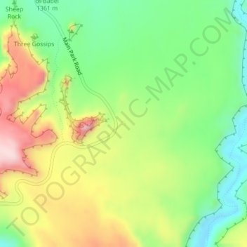
Name: Topografische Karte La Sal Mountains Viewpoint, Höhe, Relief.
Durchschnittliche Höhe: 1.347 m
Minimale Höhe: 1.217 m
Maximale Höhe: 1.522 m
Andere topografische Karten
Klicken Sie auf eine Karte, um ihre Topografie, ihre Höhe und ihr Relief anzuzeigen.
Moab
United States > Utah > Grand County
Moab, Grand County, Utah, 84532, United States
Durchschnittliche Höhe: 1.357 m
Westwater
United States > Utah > Grand County
Westwater, Grand County, Utah, United States
Durchschnittliche Höhe: 1.349 m
Cisco
United States > Utah > Grand County
Cisco, Grand County, Utah, 84515, United States
Durchschnittliche Höhe: 1.334 m
Rectory
United States > Utah > Grand County
Rectory, Grand County, Utah, United States
Durchschnittliche Höhe: 1.527 m
Delicate Arch
United States > Utah > Grand County
Delicate Arch, Delicate Arch Trail, Grand County, Utah, United States
Durchschnittliche Höhe: 1.409 m
Arches National Park
United States > Utah > Grand County
Arches National Park, Grand County, Utah, United States
Durchschnittliche Höhe: 1.476 m
Thompson Springs
United States > Utah > Grand County
Thompson Springs, Grand County, Utah, 84540, United States
Durchschnittliche Höhe: 1.583 m
Colorado River
United States > Utah > Grand County > Moab
Colorado River, Moab, Grand County, Utah, United States
Durchschnittliche Höhe: 1.668 m
Castle Valley
United States > Utah > Grand County
Castle Valley, Grand County, Utah, United States
Durchschnittliche Höhe: 1.610 m
Cottonwood Point
United States > Utah > Grand County
Cottonwood Point, Grand County, Utah, United States
Durchschnittliche Höhe: 2.346 m