
Topografische Karte Leedstown
Interaktive Karte
Klicken Sie auf die Karte, um die Höhe anzuzeigen.
Über diese Karte
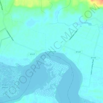
Name: Topografische Karte Leedstown, Höhe, Relief.
Ort: Leedstown, Westmoreland County, Virginia, United States (38.09152 -77.01858 38.13152 -76.97858)
Durchschnittliche Höhe: 6 m
Minimale Höhe: -1 m
Maximale Höhe: 46 m
Andere topografische Karten
Klicken Sie auf eine Karte, um ihre Topografie, ihre Höhe und ihr Relief anzuzeigen.
Hinnom
United States > Virginia > Westmoreland County
Hinnom, Westmoreland County, Virginia, 22520, United States
Durchschnittliche Höhe: 13 m
Colonial Beach
United States > Virginia > Westmoreland County
Colonial Beach, Westmoreland County, Virginia, United States
Durchschnittliche Höhe: 2 m
Latanes
United States > Virginia > Westmoreland County
Latanes, Westmoreland County, Virginia, 22443, United States
Durchschnittliche Höhe: 15 m
Latanes Pond
United States > Virginia > Westmoreland County > Laurel Grove
Latanes Pond, Laurel Grove, Westmoreland County, Virginia, United States
Durchschnittliche Höhe: 9 m