
Topografische Karte Muntinlupa
Interaktive Karte
Klicken Sie auf die Karte, um die Höhe anzuzeigen.
Über diese Karte
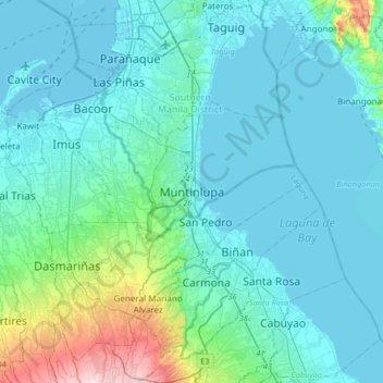
Name: Topografische Karte Muntinlupa, Höhe, Relief.
Durchschnittliche Höhe: 41 m
Minimale Höhe: -3 m
Maximale Höhe: 314 m
There are three plausible origins of the name of the city: First, is its association with the thin topsoil in the area; second, residents, purportedly replying to a question by Spaniards in the 16th century what the name of their place was, said “Monte sa Lupa”—apparently mistaking the question for what card game they were playing; third, the topographical nature of the area, where the term Monte or mountain was expanded to Muntinlupa or mountain land. Based on the 1987 Philippine constitution, it is spelled as Muntinglupa, instead of Muntinlupa.
Andere topografische Karten
Klicken Sie auf eine Karte, um ihre Topografie, ihre Höhe und ihr Relief anzuzeigen.
Sucat
Sucat, Muntinlupa, Southern Manila District, Metro Manila, Philippines
Durchschnittliche Höhe: 11 m
Alabang
Alabang, Muntinlupa, Southern Manila District, Metro Manila, 1781, Philippines
Durchschnittliche Höhe: 13 m
Cupang
Cupang, Muntinlupa, Southern Manila District, Metro Manila, Philippines
Durchschnittliche Höhe: 8 m
Bayanan
Bayanan, Muntinlupa, Southern Manila District, Metro Manila, Philippines
Durchschnittliche Höhe: 8 m
Poblacion
Poblacion, Muntinlupa, Southern Manila District, Metro Manila, 1776, Philippines
Durchschnittliche Höhe: 21 m
Ayala Alabang
Ayala Alabang, Muntinlupa, Southern Manila District, Metro Manila, Philippines
Durchschnittliche Höhe: 33 m
Tunasan
Tunasan, Muntinlupa, Southern Manila District, Metro Manila, Philippines
Durchschnittliche Höhe: 19 m
Putatan
Putatan, Muntinlupa, Southern Manila District, Metro Manila, 1772, Philippines
Durchschnittliche Höhe: 16 m
La Guerta
La Guerta, Muntinlupa, Southern Manila District, Metro Manila, 1770, Philippines
Durchschnittliche Höhe: 16 m
Cupang
Philippines > Muntinlupa > Cupang
Cupang, Muntinlupa, NCR, Fourth District, Metro Manila, 1771, Philippines
Durchschnittliche Höhe: 19 m