
Topografische Karte Hong Kong Island
Interaktive Karte
Klicken Sie auf die Karte, um die Höhe anzuzeigen.
Über diese Karte
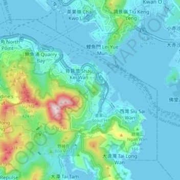
Name: Topografische Karte Hong Kong Island, Höhe, Relief.
Ort: Hong Kong Island, Eastern District, Hong Kong, China (22.24572 114.18633 22.30028 114.26160)
Durchschnittliche Höhe: 84 m
Minimale Höhe: -6 m
Maximale Höhe: 513 m
Andere topografische Karten
Klicken Sie auf eine Karte, um ihre Topografie, ihre Höhe und ihr Relief anzuzeigen.
Chai Wan Park
China > Hong Kong > Hong Kong Island
Chai Wan Park, Chai Wan Industrial Area, Chai Wan, Eastern District, Hong Kong Island, Hong Kong, China
Durchschnittliche Höhe: 96 m
Sai Wan
China > Hong Kong > Hong Kong Island
Sai Wan, Central and Western District, Hong Kong Island, Hong Kong, China
Durchschnittliche Höhe: 81 m
Mount Davis
China > Hong Kong > Hong Kong Island
Mount Davis, Hong Kong Island, Hong Kong, China
Durchschnittliche Höhe: 71 m
Mount Parker
China > Hong Kong > Hong Kong Island
Mount Parker, Hong Kong Island, Hong Kong, China
Durchschnittliche Höhe: 214 m