
Topografische Karte Cochrane
Interaktive Karte
Klicken Sie auf die Karte, um die Höhe anzuzeigen.
Über diese Karte
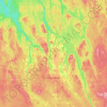
Name: Topografische Karte Cochrane, Höhe, Relief.
Durchschnittliche Höhe: 262 m
Minimale Höhe: 216 m
Maximale Höhe: 311 m
Until 1977, Timmins was used as the source for all weather readings attributed to Cochrane except for exceptional extremes, due to the overall similar climate due to proximity and topography. However, in December 1977, Cochrane temperature readings began to be taken from downtown after a noticeable difference in temperature was recorded two years prior in January 1976. However, to this day, if Cochrane's weather equipment fails at any time, the Timmins temperature readings are used due to the overall similarity.