
Topografische Karte Bacolod
Interaktive Karte
Klicken Sie auf die Karte, um die Höhe anzuzeigen.
Über diese Karte
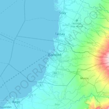
Name: Topografische Karte Bacolod, Höhe, Relief.
Durchschnittliche Höhe: 49 m
Minimale Höhe: -1 m
Maximale Höhe: 495 m
Bacólod (English: Bacolod), is derived from bakólod (Old Spelling: bacólod), the Old Hiligaynon (Old Ilonggo) (Old Spelling: Ylongo and Ilongo) word for a "hill, mound, rise, hillock, down, any small eminence or elevation", since the resettlement was founded on a stony, hilly area, now the barangay of Granada. It was officially called Ciudad de Bacólod (City of Bacolod) when Municipalidad de Bacólod (Municipality of Bacolod) was converted into a city in 1938.
Andere topografische Karten
Klicken Sie auf eine Karte, um ihre Topografie, ihre Höhe und ihr Relief anzuzeigen.
Estefania
Philippines > Negros Occidental > Bacolod > Estefania
Estefania, Bacolod, Negros Occidental, Western Visayas, 6100, Philippines
Durchschnittliche Höhe: 56 m