
Topografische Karte Cernusco sul Naviglio
Interaktive Karte
Klicken Sie auf die Karte, um die Höhe anzuzeigen.
Über diese Karte
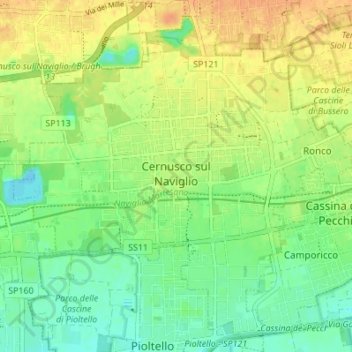
Name: Topografische Karte Cernusco sul Naviglio, Höhe, Relief.
Ort: Cernusco sul Naviglio, Milan, Lombardy, 20063, Italy (45.50024 9.29928 45.54804 9.36762)
Durchschnittliche Höhe: 134 m
Minimale Höhe: 118 m
Maximale Höhe: 151 m
The municipality of Cernusco sul Naviglio has a total area of 13.33 km2 (5 square miles) with a median altitude of 133 metres above sea level. The municipality includes the main urban area of Cernusco and the frazione of Ronco at the eastern border of the municipal area, as well as some traditional farmhouses (cassin in Lombard) still not contiguous to other urbanized parts of the municipality.[3]
Andere topografische Karten
Klicken Sie auf eine Karte, um ihre Topografie, ihre Höhe und ihr Relief anzuzeigen.
Mariotto
Italy > Lombardy > Milan > San Colombano al Lambro
Mariotto, San Colombano al Lambro, Milan, Lombardy, 26863, Italy
Durchschnittliche Höhe: 62 m
Cascina Confaloniera
Italy > Lombardy > Milan > Rosate
Cascina Confaloniera, Rosate, Unione dei Comuni I Fontanili, Milan, Lombardy, 20088, Italy
Durchschnittliche Höhe: 107 m
Municipio 8 di Milano
Italy > Lombardy > Milan > Milan
Municipio 8 di Milano, Milan, Lombardy, Italy
Durchschnittliche Höhe: 138 m
San Pietro all'Olmo
Italy > Lombardy > Milan > Cornaredo
San Pietro all'Olmo, Cornaredo, Milan, Lombardy, 20007, Italy
Durchschnittliche Höhe: 142 m
Vaiano Valle
Italy > Lombardy > Milan > Milan > Vaiano Valle
Vaiano Valle, Milan, Lombardy, 20139, Italy
Durchschnittliche Höhe: 110 m
San Colombano al Lambro
San Colombano al Lambro, Milan, Lombardy, 20078, Italy
Durchschnittliche Höhe: 73 m